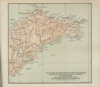
Detail View: Old Maps Collection: Map of the Eastern portion of Shantung Province showing the territory leased to Germany at Kiaochow Bay (including the neutral zone) and to Great Britain at Weihaiwei : (from Ch. Waeber's Map of North Eastern China, 1900)
|
Barcode:
|
36878003544308
|
|
Title:
|
Map of the Eastern portion of Shantung Province showing the territory leased to Germany at Kiaochow Bay (including the neutral zone) and to Great Britain at Weihaiwei : (from Ch. Waeber's Map of North Eastern China, 1900)
|
|
Contributor:
|
Veber, Karl Ivanovič, 1841-1910, bibliographic antecedent
|
|
Contributor:
|
L.L. Poates Engr'g Co., printer
|
|
Category:
|
General Maps
|
|
Type:
|
Printed
|
|
Language:
|
English
|
|
Create Year:
|
[1921]
|
|
Page No.:
|
2
|
|
Scale:
|
Scale not given.
|
|
Physical Map Dimension (cm):
|
23 x 24 cm, on sheet 30 x 30 cm
|
|
Note:
|
The map depicts the Jiaozhou Bay and Weihaiwei leased to foreign countries. Formerly as Jiao'Ao, Jiaozhou Bay became widely known to Europeans after the German Empire, in March 1898, concluded a lease with the Qing Dinasty. The area was transferred to German rule on a 99-year lease and it became known as the Kiautschou Bay concession. The area became a focus for German commercial development in China, while for the Imperial German Navy it was the base for their Far East Squadron. Because of land speculation in Germany's African colonies, a land value tax was introduced as the only tax in the colony. It was a great success, bringing wealth quite rapidly to the colony and also financial stability. With the outbreak of World War I, the Republic of China canceled the lease with the German Empire. This came into force on 23 August 1914, the day of Japan’s declaration of war on Germany, after a Japanese ultimatum for unconditional German evacuation of the colony had expired. The Republic of China declared war on Imperial Germany on 14 August 1917, since as a member of the victorious allies, China fully expected the former German colony would be returned to them. Instead, the Treaty of Versailles acceded to Japanese demands at the Paris Peace Conference and assigned all former German Pacific territories and islands north of the equator to Japan, including Jiaozhou Bay. As for the port of Weihaiwei, was a leased territory of the United Kingdom from 1898 until 1930. In 1895, the Japanese captured it in the Battle of Weihaiwei, and after Russia leased Port Arthur from China for 25 years in March 1898, the United Kingdom pressured the Chinese government into leasing Weihaiwei, with the terms of the treaty stating that it would remain in force for as long as the Russians were allowed to occupy Port Arthur. The port was primarily used as a summer anchorage for the Royal Navy's China Station and as a health resort. It also served as an occasional port of call for Royal Navy vessels in the Far East, well behind Hong Kong in the south. Other than for military matters, local administration was left under Chinese control, and the port itself remained a free port until 1923. After the Japanese victory over Russia in 1905, Japan took possession of Port Arthur. Britain extended its lease over Weihaiwei for as long as the Japanese occupied Port Arthur.
|
|
Note:
|
Original is a printed map.
|
|
Note:
|
On the right bottom corner of the map: "L.L. Poates Co. N.Y."
|
|
Note:
|
Map with graticule.
|
|
Note:
|
Relief shown by hachures.
|
|
Note:
|
Map outlined in double fillet.
|
|
Subject:
|
China
|
|
Geographic Area:
|
Shandong Sheng (China)
|
|
Relation Note:
|
Vol. 1, [pl. 2]
|
|
Pub Title:
|
Treaties and agreements with and concerning China : 1894-1919
|
|
Pub Author:
|
MacMurray, John Van Antwerp, 1881-1960
|
|
Pub Year:
|
1921
|
|
Pub location:
|
New York
|
|
Provenance:
|
Biblioteca Nacional de Portugal
|
|
Provenance:
|
http://id.bnportugal.gov.pt/bib/catbnp/430625
|
|
Provenance Call No.:
|
H.G. 19138 V.
|
|
MUST holding:
|
https://must.primo.exlibrisgroup.com/permalink/853MUST_INST/171sgkf/alma991002996549605076
|