Detail View: Old Maps Collection: Special war map of China, Corea, and Japan.
|
Barcode:
|
3687800354434C
|
|
Title:
|
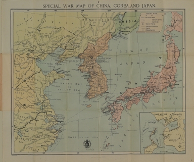
Special war map of China, Corea, and Japan.
|
|
Other Title:
|
Port Arthur.
|
|
Contributor:
|
George Philip & Son, author, publisher
|
|
Category:
|
General Maps
|
|
Type:
|
Printed
|
|
Language:
|
English
|
|
Create Year:
|
[ca. 1895]
|
|
Scale:
|
[ca. 1:4,300,000].
|
|
Physical Map Dimension (cm):
|
25 x 30 cm, on sheet 30 x 34 cm
|
|
Note:
|
The map depicts the area during the First Sino-Japanese War (1894-1895) a conflict between the Qing dynasty of China and the Empire of Japan over influence in Joseon Korea. After more than six months of unbroken successes by Japanese land and naval forces and the loss of the port of Weihaiwei, the Qing government sued for peace in February 1895. For the first time, regional dominance in East Asia shifted from China to Japan. Legend includes railways (open, constructing, and surveyed), treaty ports, submarine cables, roads, engagements. The inset map of Port Arthur shows various buildings and facilities.
|
|
Note:
|
Inset 1: Port Arthur. - Scale [ca. 1:12,000]. - 7 x 8 cm.
|
|
Note:
|
Original is a printed map, 60 x 50 cm, folded 20 x 12 cm.
|
|
Note:
|
Legend inside banderole cartouche.
|
|
Note:
|
Relief shown by hachures.
|
|
Note:
|
Map with graticule.
|
|
Note:
|
The four borders of the map with latitude and longitude lines.
|
|
Note:
|
Map outlined in double fillet. And inset outlined in simple fillet.
|
|
Subject:
|
East China Sea
|
|
Geographic Area:
|
China
|
|
Geographic Area:
|
Korea
|
|
Geographic Area:
|
Japan
|
|
Provenance:
|
Biblioteca Nacional de Portugal
|
|
Provenance:
|
http://id.bnportugal.gov.pt/bib/catbnp/554491
|
|
Provenance Call No.:
|
C.C.d. 49 A.
|
|
MUST holding:
|
https://must.primo.exlibrisgroup.com/permalink/853MUST_INST/171sgkf/alma991002997249505076
|