Detail View: Old Maps Collection: Mar del Sur. Mar Pacifico
|
Barcode:
|
36878003542339
|
|
Title:
|
Mar del Sur. Mar Pacifico
|
|
Other Title:
|
Mar Pacifico
|
|
Contributor:
|
Gerritsz, Hessel, ca. 1581-1632, cartographer
|
|
Category:
|
Nautical Chart
|
|
Type:
|
Manuscripts
|
|
Language:
|
Dutch
|
|
Language:
|
Portuguese
|
|
Language:
|
Spanish
|
|
Language:
|
Latin
|
|
Create Year:
|
1622
|
|
Scale:
|
Scale not given.
|
|
Physical Map Dimension (cm):
|
106 x 141 cm, on sheet 111 x 157 cm
|
|
Note:
|
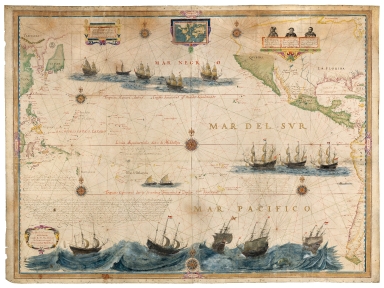
This map of the Pacific Ocean or South Ocean, was not intended as a navigational map, but as a luxurious work for the directors of the Dutch East India Company. On the West it can be seen the Asian coast, from Canton -Guangzhou- to the north of Korea; Insulindia to the east of Borneo; the Philippines, Japan, and the Solomon Islands. On the East side it is represented the Pacific coast of the Americas from California to the southern tip of South America; and, on the Atlantic side, the coast from the Tortugas to the east of Florida, as well as 'Buttons Bay' [i.e. Hudson Bay]. The three long legend captions in Dutch, two south of Timor and a third southeast of the Marquesas Islands, provide additional information about the map. The one southwest of New Guinea is in a different handwriting from the other two. Although California is depicted as a peninsula on the map, on the small planisphere on the top middle part of the map is shown as an island.
|
|
Note:
|
Original is a manuscript chart in two mounted parchment sheets, 107 x 141 cm.
|
|
Note:
|
According to the provenance library the date on the cartouche was altered and an 'X' and two 'I' were added to the original date.
|
|
Note:
|
Small planisphere in the middle top part of the map inside scroll work frame with continents outlined in yellow and the seas colored blue, 9 x 14 cm. There are represented 15 vessels, mainly Dutch ships but there are also two indigenous boats. On the bottom part of the chart there is a very large and detailed illustration of five vessels caught in a storm, one of them being English and the others Dutch, surrounded by whales. On the upper right corner of the map there are three bust portraits of Vasco Núñez de Balboa (ca. 1475-1519) Spanish explorer best known for having crossed the Isthmus of Panama to the Pacific Ocean in 1513; Fernão de Magalhães (1480-1521) the Portuguese explorer who organized the Spanish expedition to the East Indies from 1519 to 1522, resulting in the first circumnavigation of the Earth and Jacob Le Maire (ca. 1585-1616) a Dutch mariner who circumnavigated the earth in 1615 and 1616. The compass roses are seven, all 32-point, with a fleur-de-lis indicating north and a small dot on the East point. Six of them are colored blue, yellow and red and the central one is blue, yellow, red and magenta. The rhumb lines for the principal winds are black, the half winds are green and the quarter winds in red.
|
|
Note:
|
Authors name in strap work cartouche decorated with a ribbon on the left bottom corner of the map.
|
|
Note:
|
Triple scale line in Dutch miles and Spanish and English leagues inside a strap work cartouche.
|
|
Note:
|
Land masses colored green or outlined in yellow or magenta. Islands colored in the same three colors.
|
|
Note:
|
Equator line, Cancer and Capricorn in red.
|
|
Note:
|
Relief shown pictorially.
|
|
Note:
|
The four borders of the map labelled with North, South, East and West in Dutch Noord, Suydt, Oost and West.
|
|
Note:
|
Latitude lines on the left and right border of the map.
|
|
Note:
|
Border of the map in yellow, red and blue.
|
|
Note:
|
Author, scale lines, description of the portraits and legends in Dutch with place names both in Portuguese and Spanish. Equator and Tropics in Latin.
|
|
Reference:
|
Foncin, M. Catalogue des cartes nautiques sur vélin conservées au Département des cartes et plans, n° 141
|
|
Reference:
|
Pflederer, Census of Portolan Charts & Atlases: as reported and listed by the noted scholars of the genre in their works ranging from 1897 to 2008, p. 61
|
|
Subject:
|
Pacific Ocean
|
|
Geographic Area:
|
Pacific Ocean
|
|
Provenance:
|
Bibliothèque Nationale de France
|
|
Provenance:
|
GE SH ARCH-30 (RES)
|
|
Provenance Call No.:
|
https://catalogue.bnf.fr/ark:/12148/cb406204799
|
|
MUST holding:
|
https://must.primo.exlibrisgroup.com/permalink/853MUST_INST/171sgkf/alma991002971249305076
|