Detail View: Old Maps Collection: Planta geral da cidade e novo porto de Macau
|
Barcode:
|
3687800354227C
|
|
Title:
|
Planta geral da cidade e novo porto de Macau
|
|
Other Title:
|
Macau em 1840.
|
|
Other Title:
|
Macau e territorios visinhos.
|
|
Other Title:
|
[Panoramic photograph of Macao].
|
|
Contributor:
|
Alves, João Carlos, 1891-19--, creator
|
|
Contributor:
|
Pires, João Barbosa, fl. ca. 18--, creator
|
|
Contributor:
|
Bramston, William, 17---18--, cartographer
|
|
Contributor:
|
Macau. Direcção das Obras dos Portos, publisher
|
|
Contributor:
|
Tipografia Mercantil de N.T. Fernandes e Filhos, 1855-193-, editor
|
|
Contributor:
|
Hong Kong Printing Press, lithographer
|
|
Category:
|
Macao maps
|
|
Type:
|
Printed
|
|
Language:
|
Portuguese
|
|
Create Year:
|
1927
|
|
Physical Map Dimension (cm):
|
115 x 88 cm, on sheet 122 x 94 cm
|
|
Note:
|
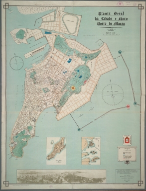
This is a large size plan of the Macau Peninsula which highlights the new landfills at north and on the Outer Harbor. The representation of buildings on the city is geometrical, typical of a plan. According to the legend, are marked State buildings, Municipal buildings, Police stations, Fire stations, water bodies and post boxes. However, there are also marked the Guia Lighthouse -to which is given the latitude and longitude, on the informational cartouche on the bottom right corner of the map- and beacons. The two insets work as a comparition of the evolution of the outline of the Macau Peninsula. The first one represents Macau in 1840 and the second is of Macau and neighbouring territories - Ilha da Lapa [Wanzai], Ilha D. João and Ilha Tai Vong Cam [today unified to form Hengqin], Taipa and Coloane.
|
|
Note:
|
Inset 1: Macau em 1840 / por W. Bramston. - Scale not given. - 18 x 13 cm. -- Inset 2: Macau e territorios visinhos. - Scale 1:80,000. - 18 x 12 cm. -- Inset 3: [Panoramic photograph of Macao]. - 9 x 58 cm.
|
|
Note:
|
Original is a colored lithograph, 123 x 94 cm, on sheet 129 x 99 cm.
|
|
Note:
|
On the bottom left corner of the map: "Editada pela Tepografia Mercantil de N.T. Fernandes e Filhos - Macau 1927". And on the right bottom corner: "Litografada pela "Hongkong Printing Press" - Hongkong 1927".
|
|
Note:
|
The first coat of arms of Macao with the motto "Cidade do nome de Deus não ha outra mais leal" above the strap work cartouche of the legend. On the main map there are two magnetic declination compasses with a half fleur de lis indicating north, one in the Inner Harbor and the other on the Outer Harbor. On inset 2 there is an arrow indicating north and south.
|
|
Note:
|
Relief shown by contours and hachures.
|
|
Note:
|
Map outlined in triple fillet with strap work squares on each corner and insets outlined in simple bold fillet.
|
|
Note:
|
City plans of Macao.
|
|
Reference:
|
Silveira, L. Ensaio de Iconografia das Cidades Portuguesas do Ultramar, vol. 3, pl. 892
|
|
Subject:
|
Macao Maps
|
|
Geographic Area:
|
Macao (China)
|
|
Provenance:
|
Biblioteca Nacional de Portugal
|
|
Provenance:
|
http://id.bnportugal.gov.pt/bib/catbnp/500498
|
|
Provenance Call No.:
|
C.C. 217 R.
|
|
MUST holding:
|
https://must.primo.exlibrisgroup.com/permalink/853MUST_INST/171sgkf/alma991002969449705076
|