Detail View: Old Maps Collection: North Atlantic Ocean
|
Barcode:
|
3687800354297J
|
|
Title:
|
North Atlantic Ocean
|
|
Original Title:
|
[Océan Atlantique Nord]
|
|
Other Title:
|
Atlantic Chart
|
|
Other Title:
|
Atlas Miller
|
|
Other Title:
|
Lopo Homem-Reineis Atlas
|
|
Contributor:
|
Homem, Lopo, fl. 1517-1565, cartographer
|
|
Contributor:
|
Reinel, Pedro, ca. 1464-ca. 1542, cartographer
|
|
Contributor:
|
Reinel, Jorge, ca. 1502-ca. 1572, cartographer
|
|
Contributor:
|
António de Holanda, 1480?-1556, illustrator
|
|
Contributor:
|
Miller, Emmanuel, 1812-1886, former owner
|
|
Contributor:
|
Santarém, Manuel Francisco de Barros e Sousa de Mesquita de Macedo Leitão e Carvalhosa, 1791-1856, 2nd viscount of, former owner
|
|
Category:
|
Nautical Chart
|
|
Type:
|
Manuscripts
|
|
Language:
|
Latin
|
|
Language:
|
Portuguese
|
|
Create Year:
|
1519
|
|
Page No.:
|
6
|
|
Scale:
|
Scale not given.
|
|
Physical Map Dimension (cm):
|
62 x 115 cm, on sheet 75 x 132 cm
|
|
Note:
|
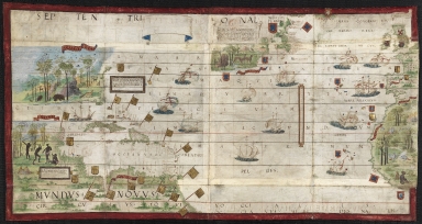
This map is from an Atlas known as Atlas Miller or Lopo Homem-Reineis Atlas. It was a joint work of cartographers Lopo Homem, Pedro Reinel and Jorge Reinel, and illustrated by Flemish miniaturist António de Holanda. It is considered one of the most beautiful Renaissance cartographic documents from Portugal. According to some authors the Atlas formed by 6 sheets is missing a 7th sheet which problaby included a map of Africa. The five sheets with the maps were sold by Jacques Charavey -a Paris bookseller- to Portuguese viscount of Santarém that later sold them to Emmanuel Clement Miller, hence the name Miller Atlas. In 1897 Millers widow sold it to the Bibliothèque Nationale de France. The mapamundi sheet was later found in an auction in London in 1930 with the no. 91 in a catalogue of Sotheby & Co. The buyer -Marcel Destombes- with the help of experts, concluded in 1939 that belonged to the Miller Atlas and in 1976 donated it to Bibliothèque Nationale de France. The title page bears a later inscription -probably after 1559- with the arms of Catherine de Medici, queen of France. It is thought to have been an offering from King Manuel I of Portugal to Francis I of France. However many authors agree that it had a political ground for it secretly denies the idea that the actual circumnavigation of the globe was possible and it was made to hinder Magellan’s voyage under the Spanish King. This sheet depicts part of the European and African, British Islands, Azores, Canaries and Cape Verde Islands. The American coasts are divided into three sections, from Labrador to Arcadia as Newfoundland (Terra Corte Regalis); from Virginia to the Gulf of Mexico (Terra Bimene) without place names; from Yucatan (Ante Yllas) to Ecuador (Mundus Novus), Terra Firme with only "Terra Corte Regalis"; from Virginia to the Gulf of Mexico (Terra Bimene) without nomenclature; from Yucatan (ante Yllas) to Ecuador (Terra Firme). The banderole on Arcadia and Labrador describes the land and states that the land was found by the Portuguese. On America there are two cartouches which also provide information about the newly discovered places. A blank banderole on the upper part of the map suggests that it might not have been finished or that new information could be added later.
|
|
Note:
|
Original is a manuscript vellum Atlas with 6 sheets with both recto and verso, 61 x 118 cm.
.
|
|
Note:
|
Title from provenance library.
|
|
Note:
|
There are a total of 20 coats of arms and 17 flags on the map, mainly from Portugal and Spain. The most important places are written in gold inside red and blue banderoles. It can be seen 13 sail ships, with nine of them carrying the cross of the Order of Christ on its sails. On Africa, South and Central America and Acadia the fauna and flora illustrations are extraordinary, depicting colorfully species of birds and mammals. A group of four native hunting and farming can be seen on the upper part of America.
|
|
Note:
|
Vertical table of leagues inside cartouche, next to latitude line.
|
|
Note:
|
The coast line is outlined in green with islands in red, blue, green and gold.
|
|
Note:
|
Relief shown pictorially.
|
|
Note:
|
Latitude line on the Atlantic. Tropic of Cancer and Equator lines in red.
|
|
Note:
|
Place names written both in black and red.
|
|
Note:
|
Map outlined in red border.
|
|
Note:
|
The map is mainly in Latin but the place names are in Portuguese.
|
|
Reference:
|
Cortesão, A. Portugaliae Monumenta Cartographica, vol. 1. p. 55-61
|
|
Reference:
|
La Mappemonde Lopo Homem et L'atlas Miller, The Geographical Journal, vol. 94, no. 6, p. 485-492
|
|
Reference:
|
Miró, M. Atlas Miller, p. 286-[296], 311-322
|
|
Reference:
|
龚缨晏. 《米勒之地图集》之谜, 地图, 02期
|
|
Reference:
|
Marques, A.P. Os Descobrimentos e o 'Atlas Miller
|
|
Reference:
|
Denucé, J. Les origines de la cartographie portugaise et les cartes des Reinel
|
|
Reference:
|
Pastoureau, M. Sur la route des deux Indes http://expositions.bnf.fr/marine/arret/03-2-2.htm
|
|
Subject:
|
Atlantic Ocean
|
|
Geographic Area:
|
Atlantic Ocean
|
|
Geographic Area:
|
Portugal
|
|
Geographic Area:
|
England
|
|
Geographic Area:
|
Ireland
|
|
Geographic Area:
|
Antilles
|
|
Geographic Area:
|
North America
|
|
Geographic Area:
|
Central America
|
|
Geographic Area:
|
South America
|
|
Geographic Area:
|
Africa
|
|
Relation Note:
|
Sheet 6 recto
|
|
Pub Title:
|
[Atlas nautique du Monde, dit Atlas Miller]
|
|
Pub Author:
|
Homem, Lopo, fl. 1517-1565, cartographer
|
|
Pub Author:
|
Reinel, Jorge, ca. 1502-ca. 1572, cartographer
|
|
Pub Author:
|
Reinel, Pedro, ca. 1464-ca. 1542, cartographer
|
|
Pub Author:
|
António de Holanda, 1480?-1556, illustrator
|
|
Pub Year:
|
1519
|
|
Pub location:
|
[Lisbon?]
|
|
Provenance:
|
Bibliothèque Nationale de France
|
|
Provenance:
|
https://catalogue.bnf.fr/ark:/12148/cb40887482g
|
|
Provenance Call No.:
|
GE AA-640 (RES)
|
|
MUST holding:
|
https://must.primo.exlibrisgroup.com/permalink/853MUST_INST/reglfj/alma991002988049405076
|