Detail View: Old Maps Collection: Mediterranean Sea
|
Barcode:
|
3687800354326C
|
|
Title:
|
Mediterranean Sea
|
|
Original Title:
|
[Mer Méditerranée]
|
|
Other Title:
|
Mediterranean Chart
|
|
Other Title:
|
Atlas Miller
|
|
Other Title:
|
Lopo Homem-Reineis Atlas
|
|
Contributor:
|
Homem, Lopo, fl. 1517-1565, cartographer
|
|
Contributor:
|
Reinel, Pedro, ca. 1464-ca. 1542, cartographer
|
|
Contributor:
|
Reinel, Jorge, ca. 1502-ca. 1572, cartographer
|
|
Contributor:
|
António de Holanda, 1480?-1556, illustrator
|
|
Contributor:
|
Miller, Emmanuel, 1812-1886, former owner
|
|
Contributor:
|
Santarém, Manuel Francisco de Barros e Sousa de Mesquita de Macedo Leitão e Carvalhosa, 1791-1856, 2nd viscount of, former owner
|
|
Category:
|
Nautical Chart
|
|
Type:
|
Manuscripts
|
|
Language:
|
Latin
|
|
Language:
|
Portuguese
|
|
Create Year:
|
1519
|
|
Page No.:
|
6
|
|
Scale:
|
Scale not given.
|
|
Physical Map Dimension (cm):
|
60 x 115 cm, on sheet 67 x 132 cm
|
|
Note:
|
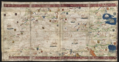
This map is from an Atlas known as Atlas Miller or Lopo Homem-Reineis Atlas. It was a joint work of cartographers Lopo Homem, Pedro Reinel and Jorge Reinel, and illustrated by Flemish miniaturist António de Holanda. It is considered one of the most beautiful Renaissance cartographic documents from Portugal. According to some authors the Atlas formed by 6 sheets is missing a 7th sheet which problaby included a map of Africa. The five sheets with the maps were sold by Jacques Charavey -a Paris bookseller- to Portuguese viscount of Santarém that later sold them to Emmanuel Clement Miller, hence the name Miller Atlas. In 1897 Millers widow sold it to the Bibliothèque Nationale de France. The mapamundi sheet was later found in an auction in London in 1930 with the no. 91 in a catalogue of Sotheby & Co. The buyer -Marcel Destombes- with the help of experts, concluded in 1939 that belonged to the Miller Atlas and in 1976 donated it to Bibliothèque Nationale de France. The title page bears a later inscription -probably after 1559- with the arms of Catherine de Medici, queen of France. It is thought to have been an offering from King Manuel I of Portugal to Francis I of France. However many authors agree that it had a political ground for it secretly denies the idea that the actual circumnavigation of the globe was possible and it was made to hinder Magellan’s voyage under the Spanish King. This sheet depicts the Mediterranean Sea with the coasts of Europe from Portugal to Caucasus, also includes Southern coasts of England and Ireland, the coasts of Africa.
|
|
Note:
|
Original is a manuscript vellum Atlas with 6 sheets with both recto and verso, 61 x 118 cm.
|
|
Note:
|
Title from provenance library.
|
|
Note:
|
There are a total of 37 coats of arms on the map, mainly in Europe but some also in Africa. There is the coat of arms of Portugal, Spain, England, Vatican and Venice and some with a half moon, a stylization for Moorish territories. The most important places are written in gold inside red and blue banderoles and are usually accompanied by illustrations of castles, there are 45 castles on the chart but also a Tower of Babel, the tablets of Moises on Mount Sinai and a Calvary on Jerusalem. It can be seen eight sail ships, with five of them carrying the cross of the Order of Christ on its sails. Two vessel are on the Atlantic, two on the Mediterranean, another two on the Black Sea and the last two on the Caspian Sea. The visible part of the Red Sea is colored red with the Caspian Sea and the Persian Gulf colored blue. On Africa are eight tents carrying flags and four figures, one of whom is on horseback.
|
|
Note:
|
The rhumb lines the principal winds are in black, the half winds in green and the quarter winds in red.
|
|
Note:
|
The coast line is outlined in green with islands in red, blue, green and gold.
|
|
Note:
|
Relief shown pictorially.
|
|
Note:
|
Latitude line on the left side of the map.
|
|
Note:
|
Place names written both in black and red.
|
|
Note:
|
Map with yellow and red border on the top, bottom and right side.
|
|
Reference:
|
Cortesão, A. Portugaliae Monumenta Cartographica, vol. 1. p. 55-61
|
|
Reference:
|
La Mappemonde Lopo Homem et L'atlas Miller, The Geographical Journal, vol. 94, no. 6, p. 485-492
|
|
Reference:
|
Miró, M. Atlas Miller, p. 286-[296], 311-322
|
|
Reference:
|
龚缨晏. 《米勒之地图集》之谜, 地图, 02期
|
|
Reference:
|
Marques, A.P. Os Descobrimentos e o 'Atlas Miller
|
|
Reference:
|
Denucé, J. Les origines de la cartographie portugaise et les cartes des Reinel
|
|
Reference:
|
Pastoureau, M. Sur la route des deux Indes http://expositions.bnf.fr/marine/arret/03-2-2.htm
|
|
Subject:
|
Mediterranean Sea
|
|
Geographic Area:
|
Mediterranean Sea
|
|
Geographic Area:
|
Europe
|
|
Geographic Area:
|
Portugal
|
|
Geographic Area:
|
Spain
|
|
Geographic Area:
|
France
|
|
Geographic Area:
|
Italy
|
|
Geographic Area:
|
England
|
|
Geographic Area:
|
Ireland
|
|
Geographic Area:
|
Germany
|
|
Geographic Area:
|
Hungary
|
|
Geographic Area:
|
Turkey
|
|
Geographic Area:
|
Greece
|
|
Geographic Area:
|
Egypt
|
|
Geographic Area:
|
Argelia
|
|
Geographic Area:
|
Libia
|
|
Geographic Area:
|
Marrocos
|
|
Geographic Area:
|
Africa
|
|
Relation Note:
|
Sheet 6 verso
|
|
Pub Title:
|
[Atlas nautique du Monde, dit Atlas Miller]
|
|
Pub Author:
|
Homem, Lopo, fl. 1517-1565, cartographer
|
|
Pub Author:
|
Reinel, Jorge, ca. 1502-ca. 1572, cartographer
|
|
Pub Author:
|
Reinel, Pedro, ca. 1464-ca. 1542, cartographer
|
|
Pub Author:
|
António de Holanda, 1480?-1556, illustrator
|
|
Pub Year:
|
1519
|
|
Pub location:
|
[Lisbon?]
|
|
Provenance:
|
Bibliothèque Nationale de France
|
|
Provenance:
|
https://catalogue.bnf.fr/ark:/12148/cb40887482g
|
|
Provenance Call No.:
|
GE AA-640 (RES)
|
|
MUST holding:
|
https://must.primo.exlibrisgroup.com/permalink/853MUST_INST/reglfj/alma991002988049505076
|