Detail View: Old Maps Collection: Carte des Indes et de la Chine : dressée sur plusieurs relations particulières rectifiées par quelques observations
|
Barcode:
|
3687800354316B
|
|
Title:
|
Carte des Indes et de la Chine : dressée sur plusieurs relations particulières rectifiées par quelques observations
|
|
Contributor:
|
Delisle, Guillaume, 1675-1726, publisher
|
|
Contributor:
|
Renard, Louis, ca. 1678-1746, publisher
|
|
Category:
|
General Maps
|
|
Type:
|
Printed
|
|
Language:
|
French
|
|
Language:
|
Portuguese
|
|
Language:
|
Spanish
|
|
Create Year:
|
1705
|
|
Scale:
|
[ca. 1:10,580,000].
|
|
Physical Map Dimension (cm):
|
63 x 65 cm, on sheet 72 x 82 cm
|
|
Note:
|
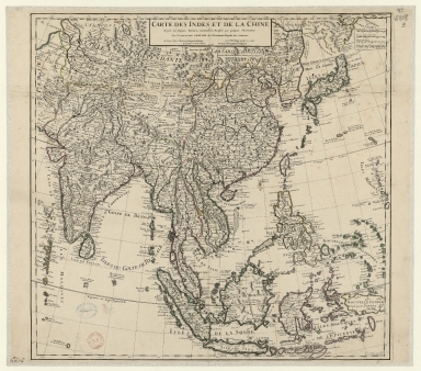
This East Indies map published by Delisle, France’s foremost 18th century cartographer, is centered in China. Although highly detailed with numerous geographical and political elements, the latter identified by dotted lines, the outline for many of the territories depicted is not that accurate. Even then this map would become the base map for the next 30 years, until the D'Anville issued his series of maps of China. The map covers much of Asia, from China, Japan, Korea and the islands of Hainan, the Philippines and Taiwan; south Papua New Guinea, Timor, Java and the Moluccas, west through Malaysia and Indonesia to Vietnam, Thailand, Tibet, Bhutan, Nepal, Cambodia, Burma, Laos, Singapore and India. Korea is already depicted as a Peninsula even though with a distorted outline. On Japan, Hokkaido is named 'Terre de Yeço ou d’Eso' and is still connected to Russia, a mistake that lasted on maps until late 18th century. Macau is marked on an island and has a note stating that it belongs to the Portuguese.
|
|
Note:
|
Original is a copperplate printed map, colored by hand, 64 x 72 cm.
|
|
Note:
|
Title at the head of the map outlined in double fillet.
|
|
Note:
|
Four scale lines on the upper right corner of the map in black and white interchangeably.
|
|
Note:
|
Relief shown pictorially.
|
|
Note:
|
Landmasses outlined in green, yellow and magenta.
|
|
Note:
|
Map with graticule.
|
|
Note:
|
Equator and Tropic of Cancer in double line.
|
|
Note:
|
The four borders of the map with latitude and longitude lines in black and white interchangeably.
|
|
Note:
|
Map outlined in double fillet.
|
|
Note:
|
Macao in East Indies maps.
|
|
Reference:
|
Donald F.L. and Edwin J.v.K. Asia in the Making of Europe: Volume III, A Century of Advance, Book Three: Southeast Asia
|
|
Reference:
|
Brooke-Hitching, E. The Phantom Atlas: The Greatest Myths, Lies and Blunders on Maps
|
|
Subject:
|
East Indies
|
|
Geographic Area:
|
Asia
|
|
Geographic Area:
|
China
|
|
Geographic Area:
|
Japan
|
|
Geographic Area:
|
Korea
|
|
Geographic Area:
|
Vietnam
|
|
Geographic Area:
|
Cambodia
|
|
Geographic Area:
|
Malaysia
|
|
Geographic Area:
|
Singapore
|
|
Geographic Area:
|
Thailand
|
|
Geographic Area:
|
Laos
|
|
Geographic Area:
|
Myanmar
|
|
Geographic Area:
|
Sumatra (Indonesia)
|
|
Geographic Area:
|
Borneo
|
|
Geographic Area:
|
Paracel Islands
|
|
Geographic Area:
|
Hainan Sheng (China)
|
|
Geographic Area:
|
Taiwan
|
|
Geographic Area:
|
India
|
|
Geographic Area:
|
Philippines
|
|
Geographic Area:
|
Papua New Guinea
|
|
Geographic Area:
|
Java (Indonesia)
|
|
Geographic Area:
|
Timor Island
|
|
Geographic Area:
|
Ceylon
|
|
Provenance:
|
Bibliothèque Nationale de France
|
|
Provenance:
|
https://catalogue.bnf.fr/ark:/12148/cb40624089g
|
|
Provenance Call No.:
|
GE DD-2987 (6808 B)
|
|
MUST holding:
|
https://must.primo.exlibrisgroup.com/permalink/853MUST_INST/171sgkf/alma991002989248405076
|