Detail View: Old Maps Collection: Planta da península e porto de Macau com as sondagens levantadas em 1884 e com o projeto do cais interior, molhe da Taipa, docas da ilha Verde e Praia Grande, dique da Taipa e revestimento marginal entre a Ilha Verde e Pac-Siac
|
Barcode:
|
3687800371236B
|
|
Title:
|
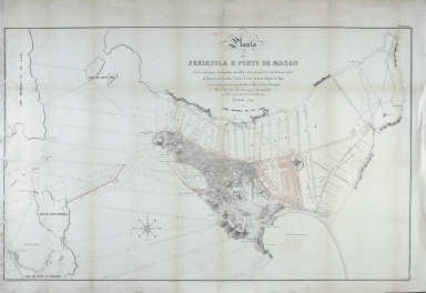
Planta da península e porto de Macau com as sondagens levantadas em 1884 e com o projeto do cais interior, molhe da Taipa, docas da ilha Verde e Praia Grande, dique da Taipa e revestimento marginal entre a Ilha Verde e Pac-Siac
|
|
Original Title:
|
Planta da peninsula e porto de Macau com as sondagens levantadas em 1884 e com o projecto do caes interior, molhe da Taipa, docas da ilha Verde e Praia Grande, dique da Taipa e revestimento marginal entre a Ilha Verde e Pac-Siac
|
|
Contributor:
|
Loureiro, Adolfo Ferreira de, 1836-1911, cartographer
|
|
Contributor:
|
Samora, Júlio César Júdice, 1845-ca. 1913, lithographer
|
|
Contributor:
|
Portugal. Imprensa Nacional, Litografia, publisher
|
|
Category:
|
Plan
|
|
Type:
|
Printed
|
|
Language:
|
Portuguese
|
|
Format:
|
1884
|
|
Page No.:
|
7
|
|
Scale:
|
1:10,000
|
|
Physical Map Dimension (cm):
|
61 x 98 cm, on sheet 70 x 102 cm
|
|
Note:
|
This map was published in the work 'O Porto de Macau: ante-projecto para o seu melhoramento' by Adolfo Ferreira de Loureiro, a Portuguese military engineer. He is known for the projects of improvement on the Ports of Leixões, Lisbon and Macau. On the chart are depicted the Macau Peninsula and the Islands of 'Lapa' , Taipa -still divided and only connected by a dam, big Taipa also appears with the name 'Kaikong'- Malau Chau and part of D. João. Being a hydrographic chart, are given soundings surveyed in 1884 with a project to the Inner Harbor, jetty of Taipa, docks of Green Island and Praia Grande, dike of Taipa and marginal covering between the Green Island and Pac-Siac. All the proposed areas of construction are colored pink. Macau is fairly detailed with the representation of buildings replaced by the geometry typical of a plan.
|
|
Note:
|
Original is a colored lithograph, 69 x 102 cm.
|
|
Note:
|
On the right bottom corner of the map: "Samora, gr."
|
|
Note:
|
Map oriented with west at the top.
|
|
Note:
|
There is an 8-point compass rose with an arrow indicating north and the initials of the winds on each point.
|
|
Note:
|
Relief shown by hachures and rock drawings. Bathymetric relief by soundings.
|
|
Note:
|
Map outlined in double fillet.
|
|
Note:
|
Macao and its surroundings.
|
|
Note:
|
City plans of Macao.
|
|
Geographic Area:
|
Macao (China)
|
|
Geographic Area:
|
Taipa Island (China)
|
|
Relation Note:
|
Estampa 7.ª
|
|
Pub Title:
|
Porto de Macau : ante-projecto para o seu melhoramento.
|
|
Pub Author:
|
Loureiro, Adolfo Ferreira de, 1836-1911
|
|
Pub Year:
|
1884
|
|
Pub location:
|
Coimbra
|
|
Provenance:
|
Biblioteca Nacional de Portugal
|
|
Provenance:
|
http://id.bnportugal.gov.pt/bib/catbnp/503752
|
|
Provenance Call No.:
|
C.C. 247//7 R.
|
|
MUST holding:
|
https://must.primo.exlibrisgroup.com/permalink/853MUST_INST/reglfj/alma991002952249605076
|