Detail View: Old Maps Collection: Plano reformado do Rio de Macau
|
Barcode:
|
3687800354295H
|
|
Title:
|
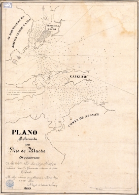
Plano reformado do Rio de Macau
|
|
Original Title:
|
Plano reformado do Rio de Macao : offerecido ao Ill.mo Sñr. João Cabral de Estefique Tenente Coronel e Governador Interino da ditta cidade
|
|
Contributor:
|
Sousa, Miguel António de, 1786-ca. 1845, cartographer
|
|
Contributor:
|
Estefique, João Cabral de, ca. 1780-1854, dedicatee
|
|
Category:
|
Chart
|
|
Type:
|
Manuscripts
|
|
Language:
|
Portuguese
|
|
Create Year:
|
1829
|
|
Scale:
|
Scale indeterminable.
|
|
Physical Map Dimension (cm):
|
70 x 50 cm, on sheet 80 x 62 cm
|
|
Note:
|
This nautical chart was made by Miguel António de Sousa, grandson of the Macanese Florentino de Sousa (ca. 1740-?). He was 1.º Lieutenant of the Navy of Goa and later was granted the habit of the Order of Aviz; for many years he was also Patrão-Mor of the Harbour of Macau. While in this position he made this hydrographic plan for navigational aid of the Inner Harbour, the Macau Peninsula and the islands of Taipa, Coloane, Lapa, D. João and Montanha. In the Macau Peninsula the city is presented in a stylized built-up area, typical of a plan, with three forts named: S. Francisco, Bom Parto and Barra. However, the most interesting point about this map is the uncommon names of the different islands. Small Taipa is named 'Maria Nunes', a woman that lived and died in Macau during the 17th century. She and her husband had a great impact on the establishment the St. Paul’s College as they were related to the Society of Jesus and gave large sums of money to the church and school. Big Taipa is named 'Kaikião' and Coloane, not completely drawn, 'Apomui' . 'Lapa' is also named 'Ribeira Grande'; Montanha is unnamed and holds the title and author information, and D. João, also unnamed, holds the explanation about the soundings.
|
|
Note:
|
Original is a manuscript map, 75 x 63 cm.
|
|
Note:
|
There is a 16-point compass rose on the back of the map with a fleur de lis indicating north.
|
|
Note:
|
Scale line in nautical miles on the right bottom corner of the map in black and white interchangeably.
|
|
Note:
|
Bathymetric relief shown by soundings.
|
|
Note:
|
Map outlined in double fillet.
|
|
Note:
|
Macao and its surroundings.
|
|
Reference:
|
Forjaz, J. Famílias Macaenses, vol. 3, p. 878
|
|
Reference:
|
BNF, https://catalogue.bnf.fr/ark:/12148/cb45384272q
|
|
Subject:
|
Chart
|
|
Geographic Area:
|
Macao (China)
|
|
Geographic Area:
|
Taipa Island (China)
|
|
Geographic Area:
|
Coloane Island (China)
|
|
Provenance:
|
Sociedade de Geografia de Lisboa
|
|
Provenance Call No.:
|
3-F-15
|
|
MUST holding:
|
https://must.primo.exlibrisgroup.com/permalink/853MUST_INST/171sgkf/alma991002983749405076
|