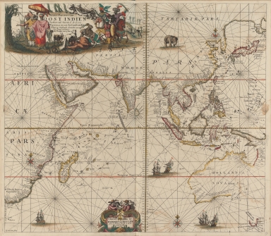
Detail View: Old Maps Collection: Nieuwe pascaert van Oost Indien

|
Barcode:
|
4687820500215
|
|
Title:
|
Nieuwe pascaert van Oost Indien
|
|
Original Title:
|
Nieuwe pascaert van Oost Indien
|
|
Contributor:
|
Keulen, Johannes van, 1654-1715
|
|
Category:
|
Sea Charts
|
|
Type:
|
Printed
|
|
Language:
|
Latin
|
|
Create Year:
|
1680
|
|
Format:
|
JPEG, 8360 × 6622, 66.5MB
|
|
Scale:
|
Scale not given
|
|
Physical Map Dimension (cm):
|
52 × 59
|
|
Note:
|
Shows Indian Ocean and coasts of eastern Africa, India, East Indies, and Australia. "Verthoonende hen van C. de Bona Esperanca tot aen het Landt van Eso ; Geleyt op Waßende Graeden en van Veel Fouten verbetert ; Met Priviligie voor 15 Iaar"
|
|
Note:
|
The map did not mark the position of Macao, but indicates New Macao (Nova Macao) on the north shore of the Gulf of Tonkin, which is worthy of attention.
|
|
Note:
|
Macao in Asia Maps
|
|
Subject:
|
Nautical charts
|
|
Geographic Area:
|
Southeast Asia
|
|
Geographic Area:
|
Indian Ocean
|
|
Geographic Area:
|
China
|
|
Pub Title:
|
Le grand nouvel atlas de le mer, ou Monde aquatique. |b Estant augmenté, & nous represente touttes les costes maritimes de la terre, consistant en tres belles cartes, si bien plattes, que celles qui ont des degrés croissant, dont il y en a aucunes corrigées de la variation du buxolle. Ce qui se voit au tire des cartes. Fort utile a des mariniers, pilottes, & amateurs de la grande navigation.
|
|
Pub Author:
|
Keulen, Johannes van, 1654-1715
|
|
Pub Year:
|
1682
|
|
Pub location:
|
Amsterdam
|
|
Provenance:
|
Harvard Map Collection - Harvard College Library
|
|
MUST holding:
|
http://10.20.100.239/record=b1390023
|