Detail View: Old Maps Collection: View of the city of Macau from the sea side
|
Barcode:
|
36878003712147
|
|
Title:
|
View of the city of Macau from the sea side
|
|
Original Title:
|
Вид города Макао из Морской стороны
|
|
Other Title:
|
Vid goroda Makao s morskoĭ storony
|
|
Contributor:
|
Tilesius von Tilenau, Wilhelm Gottlieb, 1769-1857, author
|
|
Contributor:
|
Maritime Printing House, printer
|
|
Category:
|
City Plans & Views
|
|
Type:
|
Printed
|
|
Language:
|
Russian
|
|
Create Year:
|
[1813]
|
|
Page No.:
|
96
|
|
Scale:
|
Scale not given.
|
|
Physical Map Dimension (cm):
|
19 x 40 cm
|
|
Note:
|
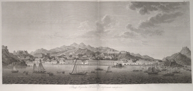
This is a view of Macao seen from the sea drawn by Wilhelm Gottlieb Tilesius von Tilenau, a German naturalist and explorer, physician, draftsman and engraver. Between 1803 and 1806 he participated as a ship's doctor, marine biologist and expedition artist on the frigate Nadezhda in the first Russian circumnavigation of the globe under the Russian Ivan Fedorovich Kruzenshtern. The Nadezhda departed from Kronstadt on the Baltic Sea, and he joined it at Copenhage. The Nadezhda then sailed past the Canary Islands and Brazil, around Cape Horn and across the Pacific Ocean to Japan, stopping at the Marquesas and Hawaiian islands, and also at Kamchatka. After visiting Japan, the Nadezhda set off towards Alaska, then sailed past China to the Indian Ocean, around Africa and back to the Baltic. Tilesius made numerous sketches and watercolors during the trip. His illustrated report on the expedition was published in 1813 in the book 'Puteshestvi︠e︡ vokrug svi︠e︡ta v 1803, 4, 5, i 1806 godakh' by Ivan Fedorovich Kruzenshtern. However, he did not win public recognition. The view depicts a busy inner harbor of Macao with people on land and with a vast number of vessels both western and Chinese, which asserts the city as an important trade center. There forts built in strategic locations are easily identified. It can be seen the Barra fort at the right side with the Guia fort on top of the hill hoisting a Portuguese flag. At the center it can also be seen the great Monte fort.
|
|
Note:
|
Original is a copperplate printed view in the book 'Puteshestvi︠e︡ vokrug svi︠e︡ta v 1803, 4, 5, i 1806 godakh' by Ivan Fedorovich Kruzenshtern, 32 x 75 cm.
|
|
Note:
|
City plans of Macao.
|
|
Reference:
|
柳若梅. 歷史上俄羅斯人畫澳門的最早記錄 http://www.icm.gov.mo/rc/viewer/10098/2205
|
|
Geographic Area:
|
Macao (China)
|
|
Relation Note:
|
Vol. 3, tab. XCVI
|
|
Pub Title:
|
Путешествие вокруг света в 1803, 4, 5 и 1806 годах : по повелению его имераторского величества Александра Первого, на кораблях "Надежде" и "Неве", под начальством флота капитана-лейтенанта, ныне капитана второго ранга, Крузенштерна, Государственного адмиралтейского департамента и Императорской Академии наук члена
|
|
Pub Author:
|
Kruzenshtern, Ivan Fedorovich, 1770-1846
|
|
Pub Year:
|
1809-1813
|
|
Pub location:
|
Saint Petersburg
|
|
Provenance:
|
Library of Congress
|
|
Provenance:
|
https://lccn.loc.gov/2003627000
|
|
Provenance Call No.:
|
G1036 .K7 1813 Vault fol.
|
|
MUST holding:
|
https://must.primo.exlibrisgroup.com/permalink/853MUST_INST/1dp55m9/alma991002945049705076
|