Detail View: Old Maps Collection: Carta de Portugal e suas colonias
|
Barcode:
|
3687800371217A
|
|
Title:
|
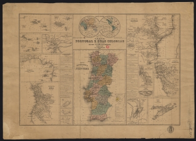
Carta de Portugal e suas colonias
|
|
Other Title:
|
Archipelago dos Açores.
|
|
Other Title:
|
Archipelago da Madeira.
|
|
Other Title:
|
Mappa mundi.
|
|
Other Title:
|
Governo Geral de Moçambique.
|
|
Other Title:
|
Governo Geral de Cabo Verde.
|
|
Other Title:
|
Governo Geral de Senegambia, Cacheu e Bissau.
|
|
Other Title:
|
Governo Geral de S. Thome e Principe.
|
|
Other Title:
|
Carta Geographica de Portugal.
|
|
Other Title:
|
Hespanha Antiga.
|
|
Other Title:
|
Governo do Districto de Damão.
|
|
Other Title:
|
Governo Geral dos Estados da India.
|
|
Other Title:
|
Governo da Praça de Diu.
|
|
Other Title:
|
Governo Geral de Angola.
|
|
Other Title:
|
Porto de Loanda.
|
|
Other Title:
|
Bahia de Benguella.
|
|
Other Title:
|
Bahia de Mossamedes.
|
|
Other Title:
|
Governo Geral de Macau.
|
|
Other Title:
|
Governo de Timor.
|
|
Contributor:
|
Castelo Branco, Hugo Goodair de Lacerda, 1836-1930, author
|
|
Contributor:
|
Carvalho, Augusto Luís Nunes de, 1843-1909, lithographer, publisher
|
|
Category:
|
General Maps
|
|
Type:
|
Printed
|
|
Language:
|
Portuguese
|
|
Create Year:
|
1873
|
|
Scale:
|
Scales vary.
|
|
Physical Map Dimension (cm):
|
36 x 53 cm, on sheet 44 x 62 cm
|
|
Note:
|
The map is headed with a world map where Portugal and its colonies of the 16th and 19th centuries are marked. Right underneath, at the center, there is a map of continental Portugal with the intermunicipal communities in different colors and marked with all the cities, villages, railways, rivers, forts, lighthouses, etc. etc. with an inset with Lusitania and old Spain. At the left side of this map there is a column which states all the Portuguese colonies on the West with a brief description and their respective maps. On the right side are the Portuguese colonies of the West in which Macau is included. Macau is described as first being named City with the Name of the God of Macau and that the Chinese emperor gifted it to the Portuguese in 1557 as an acknowledgment for help against pirate attacks in Guangzhou. It has 40.000 inhabitants and Timor is politically dependent of it. The buildings on the Macau map are represented geometrically as typical of a plan and are identified the Border Gate and the Forts. It can also be seen the Green Island, Wanzai and the north part of the islands of Taipa.
|
|
Note:
|
Map 1: Archipelago dos Açores. - Scale [ca. 1: 6000000]. - 6 x 10 cm. -- Map 2: Archipelago da Madeira. - Scale [ca. 1:1600000]. - 6 x 7 cm. -- Map 3: Mappa mundi. - Scale [1:317000000]. - 11 x 17 cm. -- Map 4: Governo Geral de Moçambique. - Scale [ca. 1:9100000]. - 16 x 18 cm. -- Map 5: Governo Geral de Cabo Verde. - Scale [ca. 1:4300000]. - 7 x 8 cm. -- Map 6: Governo Geral de Senegambia, Cacheu e Bissau. - Scale [ca. 1: 3000000]. - 7 x 10 cm. -- Map 7: Governo Geral de S. Thome e Principe. - Scale [ca. 1:9700000]. - 9 x 13 cm. -- Map 8: Carta Geographica de Portugal. - Scale 1:2000000. - 25 x 17 cm. -- Inset 1: Hespanha Antiga. - Scale not given. - 3 x 3 cm. -- Map 9: Governo do Districto de Damão. - Scale [ca. 1:520000]. - 7 x 5 cm. -- Map 10: Governo Geral dos Estados da India. - Scale [ca. 1:720000]. - 13 x 9 cm. -- Map 11: Governo da Praça de Diu. - Scale not given. - 4 x 5 cm. -- Map 12: Governo Geral de Angola. - Scale [ca. 1:11000000]. - 14 x 13 cm. -- Map 13: Porto de Loanda. - Scale not given. - 4 x 4 cm. -- Map 14: Bahia de Benguella. - Scale not given. - 2 x 4 cm. -- Map 15: Bahia de Mossamedes. - Scale not given. - 3 x 4 cm. -- Map 16: Governo Geral de Macau. - Scale not given. - 9 x 7 cm. -- Map 17: Governo de Timor. - Scale [ca. 1:6000000]. - 9 x 11 cm.
|
|
Note:
|
Original is a printed map, 44 x 65 cm, on sheet 54 x 77 cm.
|
|
Note:
|
Map formed by 17 maps and one inset.
|
|
Note:
|
The 'Mappa mundi' and 'Carta Geographica de Portugal' with its inset are colored.
|
|
Note:
|
The maps 8-10 and 16 have scale lines in black and white interchangeably.
|
|
Note:
|
The maps 1-2, 4-8, 12 and 17 have the four borders with latitude and longitude lines.
|
|
Note:
|
Relief shown by hachures and bathymetric relief by soundings and isolines.
|
|
Note:
|
Map outlined in double fillet.
|
|
Note:
|
Macao and its surroundings.
|
|
Geographic Area:
|
World
|
|
Geographic Area:
|
Macao (China)
|
|
Provenance:
|
Biblioteca Nacional de Portugal
|
|
Provenance:
|
http://id.bnportugal.gov.pt/bib/catbnp/319397
|
|
Provenance Call No.:
|
C.C. 1065 A.
|
|
MUST holding:
|
https://must.primo.exlibrisgroup.com/permalink/853MUST_INST/1dp55m9/alma991002945249605076
|