Detail View: Old Maps Collection: Carta hidrográfica da província de Macau
|
Barcode:
|
36878003712259
|
|
Title:
|
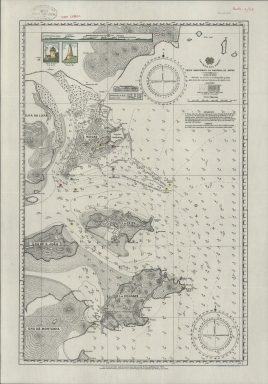
Carta hidrográfica da província de Macau
|
|
Other Title:
|
Panorama de Macau e ilhas visto do ponto A.
|
|
Other Title:
|
Farol da Guia visto de SE.
|
|
Other Title:
|
Farol de Ka-Hó visto de NE.
|
|
Contributor:
|
Macau. Direcção das Obras dos Portos, author
|
|
Contributor:
|
Macau. Serviços de Hidrografia da Capitania dos Portos, author, publisher
|
|
Contributor:
|
Litografia Sin Chon & Cia., fl. 1944-1954, lithographer
|
|
Category:
|
City Plans & Views
|
|
Type:
|
Printed
|
|
Language:
|
Portuguese
|
|
Create Year:
|
1954
|
|
Scale:
|
1:40,000.
|
|
Physical Map Dimension (cm):
|
45 x 30 cm, on sheet 50 x 35 cm
|
|
Note:
|
This is a hydrographic chart was first published in 1928 and later updated with the soundings in 1954. The map depicts Macau, Taipa, Coloane, Wanzai -here named Ilha da Lapa-, Montanha, S. João and the Green Island. On Macau the depiction of buildings is geometrical, typical of a plan. On land are marked the most important places such as the Border Gate, the Forts, the Ports, barracks, customhouses, and in Taipa the shooting range. The lighthouses are marked with a colored star. All the elements on the map together with the legend underneath the title on the top right corner are in aid of easily navigating the area.
|
|
Note:
|
Inset 1: Panorama de Macau e ilhas visto do ponto A. - 1 x 15 cm. -- Inset 2: Farol da Guia visto de SE. - 3 x 2 cm. -- Inset 3: Farol de Ka-Hó visto de NE. - 3 x 2 cm.
|
|
Note:
|
Original is a colored lithography, 44 x 29 cm, on sheet 49 x 35 cm.
|
|
Note:
|
On the right bottom corner: 'Litografia Sin Chon e Cia.'
|
|
Note:
|
Colored coat of arms of the Portuguese Republic on top of the title and colored Portuguese flag on the Border Gate. The three insets are also colored.
|
|
Note:
|
On the map there are two magnetic declination compasses with a star indicating north.
|
|
Note:
|
Scale line underneath the title on the right top corner of the map in black and white interchangeably.
|
|
Note:
|
Relief shown by hachures and spot heights. Bathymetric relief by soundings.
|
|
Note:
|
Map with graticule.
|
|
Note:
|
The four borders of the map with latitude and longitude lines in black and white interchangeably.
|
|
Note:
|
Map outlined in simple fillet and insets outlined in double fillet.
|
|
Note:
|
Macao and its surroundings.
|
|
Note:
|
City plans of Macao.
|
|
Geographic Area:
|
Macao (China)
|
|
Geographic Area:
|
Taipa Island (China)
|
|
Geographic Area:
|
Coloane Island (China)
|
|
Provenance:
|
Biblioteca Pública de Évora
|
|
Provenance:
|
http://evoraopacgib.bibliopolis.info/OPAC/b.aspx?CLI=EVORA&X1=Evora_GiB_Catalogo&id=76781
|
|
Provenance Call No.:
|
BPE-RES Pasta 9 nº 78
|
|
MUST holding:
|
https://must.primo.exlibrisgroup.com/permalink/853MUST_INST/1dp55m9/alma991002951849605076
|