Detail View: Old Maps Collection: Mappa da barra de Macáo
|
Barcode:
|
36878003712158
|
|
Title:
|
Mappa da barra de Macáo
|
|
Other Title:
|
Mapa da Barra de Macau
|
|
Contributor:
|
Rendo, Custódio de Azevedo, cartographer
|
|
Category:
|
City Plans & Views
|
|
Type:
|
Printed
|
|
Language:
|
Portuguese
|
|
Create Year:
|
1772
|
|
Scale:
|
Scale not given.
|
|
Physical Map Dimension (cm):
|
47 x 26 cm, on sheet 48 x 28 cm
|
|
Note:
|
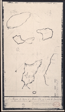
This map was made by Custódio de Azevedo Rendo pilot of the ship Nossa Senhora da Penha de França, São Francisco de Paula Almas that in 1770 arrived in Lisbon coming from China. In March 18th of the next year left Lisbon to Macau. Sailed in the East Seas and participated in combat with Marathas in 1772. By inspection on September 11th, 1776, was judged incapable of service and dismounted. The map depicts the Macao Peninsula with the Border Gate and the Forts Monte, Guia, São Francisco, Penha, Bom Parto and Barra, all of them depicted with a Portuguese flag. It it also present the A-Ma Temple -named only Pagode. The Taipa islands are still divided in Big Taipa and Small Taipa- named on he map as only 'Taipa Quebrada'. There is also Coloane, Montanha and D. João with part of Ilhas do Bugio and Lapa. There are given quite a few soundings from Macau Inner Harbor to the path between Taipa until Coloane. A very curious and unique feature of this map, that we couldn't find in any other, is the mention of three personal names on the Macau Inner Harbor part of the map. The first is the 'Cazas de Simão Vic.te' i.e. Houses of Simão Vicente. Simão Vicente Rosa (ca. 1718-1773) was a Portuguese that arrived in Macau in the year of 1738 and inherited a very big fortune from his uncle, Manuel Vicente Rosa. He later became owner of the Green Island, given to him as payment for money owned by the Jesuits. He was also procurator of the Leal Senado in the years 1745, 1759, 1761, 1764 and 1771. Another mention is of António José da Costa (d. 1781) that came to Macau as a request by the Jesuits and became one of the most prosperous citizens of his time. He was Macau governor since 1781 until his death. The last mention is of 'João Rib.ro", full name João Ribeiro Guimarães, a rich merchant and ship owner. Just like Simão Vicente Rosa, he was procurator of the Leal Senado in the years 1755, 1765 and 1782. As all of them were ship owners and the author of the map was a pilot himself, it makes sense that he knew them. However, it doesn't make it less curious as this is not very common on maps in general and Macau maps specifically. Regardless, it is a statement of their importance at the time, so much for their names to appear on a map of the Peninsula.
|
|
Note:
|
Original is a manuscript map, 45 x 28 cm.
|
|
Note:
|
32-point compass rose with a half fleur de lis indicating north.
|
|
Note:
|
Vertical scale line on the right bottom corner of the map.
|
|
Note:
|
Bathymetric relief shown by soundings.
|
|
Note:
|
Oriented with South at the top.
|
|
Note:
|
Map outlined in simple fillet.
|
|
Note:
|
Macao and its surroundings.
|
|
Note:
|
City plans of Macao.
|
|
Geographic Area:
|
Macao (China)
|
|
Geographic Area:
|
Taipa Island (China)
|
|
Geographic Area:
|
Coloane Island (China)
|
|
Provenance:
|
Library of Congress
|
|
Provenance:
|
https://lccn.loc.gov/89696137
|
|
Provenance Call No.:
|
G7823.M2P55 1772 .R4 MLC
|
|
MUST holding:
|
https://must.primo.exlibrisgroup.com/permalink/853MUST_INST/1dp55m9/alma991002945049605076
|