Detail View: Old Maps Collection: Plan de la ville et du port de Macao
|
Barcode:
|
3687800371219C
|
|
Title:
|
Plan de la ville et du port de Macao
|
|
Contributor:
|
Bellin, Jacques-Nicolas, 1703-1772, cartographer
|
|
Category:
|
City Plans & Views
|
|
Type:
|
Printed
|
|
Language:
|
French
|
|
Create Year:
|
[1764]
|
|
Page No.:
|
57
|
|
Scale:
|
[ca. 1:2,800] (E 113°32'49"/N 22°11'59")
|
|
Physical Map Dimension (cm):
|
22 x 17 cm, on sheet 31 x 21 cm
|
|
Note:
|
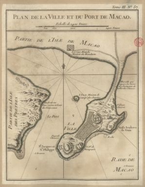
he map depicts a stylized built-up area, typical of a plan. However, the city walls and fortifications are in considerable detail which might imply a military use to the map. It identifies the Border Gate with an explanation of its purpose; the Green Island used by the Jesuits; the unnamed Chinese village of Mong-Há and the A-Ma Temple (Pagode Chinoise). However, the most detail is given to military information such as where the vessels are built in Lapa (Partie de l'Isle des Pretres) and its Batery (Batt); the location of the harbors; the major fortification of Monte (N.D. de la Montaigne); the Barra fortress (S.t Jacques et S.t Philippe); the bastion of Nossa Senhora do Bom Parto (N.D.e de Bomparto) and even a shore battery under the Guia fort (Nossa Senhora da Guia) where a lighthouse was built years later. This is a very common map of Macau that was published in many sizes and by many authors throughout the years.
|
|
Note:
|
Original is a copperplate printed map in the 'Le petit atlas maritime: recueil de cartes et plans des quatre parties du monde', 32 x 28 cm.
|
|
Note:
|
There is a 16-point compass rose with a fleur-de-lis indicating north. Rhumb lines for the principal winds are bold and the half-winds are doted.
|
|
Note:
|
Scale line underneath the title in black and white interchangeably.
|
|
Note:
|
Relief shown pictorially and by hachures.
|
|
Note:
|
Map outlined in double fillet.
|
|
Note:
|
Macao and its surroundings.
|
|
Note:
|
City plans of Macao.
|
|
Reference:
|
NLA https://nla.gov.au/nla.cat-vn3427979
|
|
Geographic Area:
|
Macao (China)
|
|
Geographic Area:
|
Green Island
|
|
Geographic Area:
|
Lapa Island
|
|
Relation Note:
|
Tome III, n.º 57
|
|
Pub Title:
|
Petit atlas maritime : recueil de cartes et plans des quatre parties du monde
|
|
Pub Author:
|
Bellin, Jacques-Nicolas, 1703-1772
|
|
Pub Year:
|
1764
|
|
Pub location:
|
[Paris]
|
|
Provenance:
|
Biblioteca Nacional de Portugal
|
|
Provenance:
|
http://id.bnportugal.gov.pt/bib/catbnp/604917
|
|
Provenance Call No.:
|
C.A. 62 V.
|
|
MUST holding:
|
https://must.primo.exlibrisgroup.com/permalink/853MUST_INST/1dp55m9/alma991002943849805076
|