Detail View: Old Maps Collection: Planta da Ilha de Coloane
|
Barcode:
|
36878003712237
|
|
Title:
|
Planta da Ilha de Coloane
|
|
Other Title:
|
Reconhecimento da Enseada de Coloane
|
|
Contributor:
|
Portugal. Comissão de Cartografia das Colónias, author, publisher
|
|
Contributor:
|
Ribeiro, Alberto Teófilo, creator
|
|
Contributor:
|
Dinis, Miranda, 1858 -1943, lithographer
|
|
Category:
|
City Plans & Views
|
|
Type:
|
Printed
|
|
Language:
|
Portuguese
|
|
Create Year:
|
1912
|
|
Page No.:
|
4
|
|
Scale:
|
1:10,000
|
|
Physical Map Dimension (cm):
|
36 x 47 cm, on sheet 39 x 51 cm
|
|
Note:
|
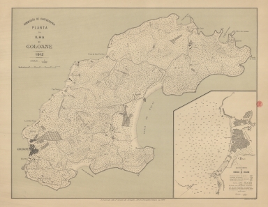
This a plan of the Island of Coloane where the little village is depicted geometrically, typical of a plan. On the island are marked the places considered of most importance such as the Fort, the barracks, the Hospital and a Pagoda. The inset on the right bottom corner is a hydrographic plan of the Coloane bay with a detail of the Coloane village, locating the fort, the barrack, the military post and the school.
|
|
Note:
|
Original is a lithograph printed colored map, 36 x 47 cm.
|
|
Note:
|
On the right bottom corner of the map: "M. Diniz red. e lith."
|
|
Note:
|
Both scale lines of the map and inset in meters underneath their respective title.
|
|
Note:
|
Relief shown by form lines, spot heights and rock drawings and bathymetric soundings on the inset.
|
|
Note:
|
Map outlined in double fillet.
|
|
Note:
|
City plans of Macao.
|
|
Geographic Area:
|
Coloane Island (China)
|
|
Relation Note:
|
[4]
|
|
Pub Title:
|
Atlas de Macau
|
|
Pub Author:
|
Portugal. Comissão de Cartografia
|
|
Pub Year:
|
1912
|
|
Pub location:
|
[S.l.]
|
|
Provenance:
|
Biblioteca Nacional de Portugal
|
|
Provenance:
|
http://id.bnportugal.gov.pt/bib/catbnp/280142
|
|
Provenance Call No.:
|
C.A. 88 A.
|
|
MUST holding:
|
https://must.primo.exlibrisgroup.com/permalink/853MUST_INST/1dp55m9/alma991002951849805076
|