Detail View: Old Maps Collection: Esboço das Ilhas da Taipa
|
Barcode:
|
36878003712204
|
|
Title:
|
Esboço das Ilhas da Taipa
|
|
Contributor:
|
Portugal. Comissão de Cartografia das Colónias, author, publisher
|
|
Contributor:
|
Dinis, Miranda, 1858 -1943, lithographer
|
|
Category:
|
City Plans & Views
|
|
Type:
|
Printed
|
|
Language:
|
Portuguese
|
|
Create Year:
|
1912
|
|
Page No.:
|
3
|
|
Scale:
|
1:10,000
|
|
Physical Map Dimension (cm):
|
33 x 46 cm, on sheet 39 x 52 cm
|
|
Note:
|
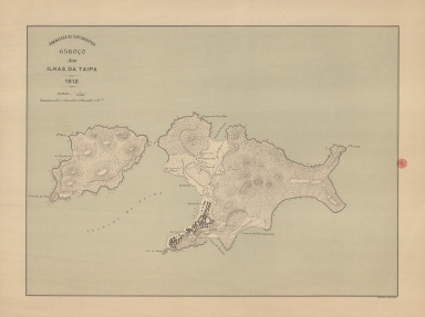
This map depicts the two islands of Taipa that were not unified until the 20th century. Taipa Grande or Taipa Quebrada -氹仔- is the main Island and Taipa Pequena -小潭山- the smaller one. The depiction of buildings is geometrical typical of a plan with the most important buildings marked: the Forts, the Port, churches and hospitals, cemeteries and pagodas and even some beaches and the shooting range.
|
|
Note:
|
Original is a lithograph printed colored map, 35 x 45 cm.
|
|
Note:
|
On the right bottom corner of the map: "M. Diniz comp.ª e lith."
|
|
Note:
|
Scale line in meters underneath the title on the left upper corner of the map.
|
|
Note:
|
Relief shown pictorially, by hachures, spot heights and rock drawings.
|
|
Note:
|
Map outlined in double fillet.
|
|
Note:
|
City plans of Macao.
|
|
Geographic Area:
|
Taipa Island (China)
|
|
Relation Note:
|
[3]
|
|
Pub Title:
|
Atlas de Macau
|
|
Pub Author:
|
Portugal. Comissão de Cartografia
|
|
Pub Year:
|
1912
|
|
Pub location:
|
[S.l.]
|
|
Provenance:
|
Biblioteca Nacional de Portugal
|
|
Provenance:
|
http://id.bnportugal.gov.pt/bib/catbnp/280142
|
|
Provenance Call No.:
|
C.A. 88 A.
|
|
MUST holding:
|
https://must.primo.exlibrisgroup.com/permalink/853MUST_INST/1dp55m9/alma991002951749705076
|