Detail View: Old Maps Collection: Planta e perfil da fortaleza da Barra de Macáo
|
Barcode:
|
36878003712169
|
|
Title:
|
Planta e perfil da fortaleza da Barra de Macáo
|
|
Other Title:
|
Planta e perfil da fortaleza da Barra de Macau
|
|
Contributor:
|
A.E.P., fl. 1850, author
|
|
Category:
|
City Plans & Views
|
|
Type:
|
Printed
|
|
Language:
|
Portuguese
|
|
Create Year:
|
1850
|
|
Scale:
|
Scale not given.
|
|
Physical Map Dimension (cm):
|
38 x 55 cm, on sheet 46 x 61 cm
|
|
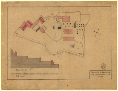
Note:
|
The map depicts the plan of the Barra fort with its buildings coloured pink. There is a line that crosses the whole fort to which is given a profile on the left bottom corner of the map that help us perceive the difference in ground level inside the fort.
|
|
Note:
|
Original is a manuscript map, 46 x 60 cm.
|
|
Note:
|
A 4-point compass rose with a fleur de lis indicating north.
|
|
Note:
|
Scale line in meters in black and white interchangeably on the left bottom corner of the map.
|
|
Note:
|
Relief shown pictorially.
|
|
Note:
|
Map outlined in double fillet.
|
|
Note:
|
Images of Macao.
|
|
Reference:
|
Boletim das bibliothecas e archivos nacionaes, nº 1, 6º ano, Jan./March 1907, p. 79
|
|
Subject:
|
Fortification
|
|
Subject:
|
Military engineering
|
|
Geographic Area:
|
Macao (China)
|
|
Provenance:
|
Biblioteca Nacional de Portugal
|
|
Provenance:
|
http://id.bnportugal.gov.pt/bib/catbnp/1668936
|
|
Provenance Call No.:
|
D. 205 A.
|
|
MUST holding:
|
https://must.primo.exlibrisgroup.com/permalink/853MUST_INST/1dp55m9/alma991002945249705076
|