Detail View: Old Maps Collection: Planta da cidade de Macau
|
Barcode:
|
36878003712215
|
|
Title:
|
Planta da cidade de Macau
|
|
Contributor:
|
Portugal. Comissão de Cartografia das Colónias, author, publisher
|
|
Contributor:
|
Dinis, Miranda, 1858 -1943, lithographer
|
|
Category:
|
City Plans & Views
|
|
Type:
|
Printed
|
|
Language:
|
Portuguese
|
|
Create Year:
|
1912
|
|
Page No.:
|
2
|
|
Scale:
|
1:10,000
|
|
Physical Map Dimension (cm):
|
45 x 35 cm, on sheet 52 x 40 cm
|
|
Note:
|
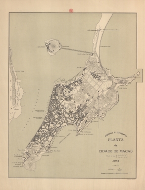
This map depicts Macau and the Green Island. The depiction of buildings is geometrical typical of a plan with the most important buildings marked: the Border Gate, the Forts, the Lighthouse, the churches and hospitals. The latitude and longitude of the Guia Lighthouse is even given underneath the title. On this map are also marked a few places that no longer exist in Macau as is the case of the Cacilhas Beach, the Bateria 1.º Dezembro right under the Fort of S. Francisco, the Bishop Bay and the Beach of Areia Preta.
|
|
Note:
|
Original is a lithograph printed map, 45 x 35 cm.
|
|
Note:
|
On the right bottom corner of the map: "M. Diniz red. e lith."
|
|
Note:
|
Simple 4-point compass rose on the map.
|
|
Note:
|
Scale line in meters on the right bottom corner of the map.
|
|
Note:
|
Relief shown by hachures, spot heights and rock drawings.
|
|
Note:
|
Map outlined in double fillet.
|
|
Note:
|
City plans of Macao.
|
|
Geographic Area:
|
Macao (China)
|
|
Relation Note:
|
[2]
|
|
Pub Title:
|
Atlas de Macau
|
|
Pub Author:
|
Portugal. Comissão de Cartografia
|
|
Pub Year:
|
1912
|
|
Pub location:
|
[S.l.]
|
|
Provenance:
|
Biblioteca Nacional de Portugal
|
|
Provenance:
|
http://id.bnportugal.gov.pt/bib/catbnp/280142
|
|
Provenance Call No.:
|
C.A. 88 A.
|
|
MUST holding:
|
https://must.primo.exlibrisgroup.com/permalink/853MUST_INST/reglfj/alma991002951749805076
|