Detail View: Old Maps Collection: Macau e territorios visinhos
|
Barcode:
|
3687800371218B
|
|
Title:
|
Macau e territorios visinhos
|
|
Other Title:
|
Macau e territórios vizinhos
|
|
Contributor:
|
Portugal. Comissão de Cartografia das Colónias, author, publisher
|
|
Contributor:
|
Dinis, Miranda, 1858 -1943, lithographer
|
|
Category:
|
City Plans & Views
|
|
Type:
|
Printed
|
|
Language:
|
Portuguese
|
|
Create Year:
|
1912
|
|
Page No.:
|
1
|
|
Scale:
|
1:80,000 (E 113º26'--E 113º38'/N 22º22'--N22º04')
|
|
Physical Map Dimension (cm):
|
47 x 33 cm, on sheet 53 x 40 cm
|
|
Note:
|
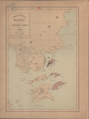
This map depicts Macau and its surroundings, with Macau Peninsula, the Green Island, the Taipa Islands and Coloane colored pink. It is also seen Wanzai -here named 'Ilha Patera ou Ilha da Lapa'- and Hengqin still divided in two islands -'Ilha Macariai ou D. João' and 'Ilha Tai-Vong-Cam ou Montanha'- with representation of the shallow waters. Macau depiction of buildings is geometrical typical of a plan and it is marked the Border Gate, the Forts and the Lighthouse.
|
|
Note:
|
Original is a printed map, 46 x 33 cm.
|
|
Note:
|
On the right bottom corner of the map: "M. Diniz comp.ou e lith."
|
|
Note:
|
Relief shown by hachures.
|
|
Note:
|
The four borders of the map with latitude and longitude lines.
|
|
Note:
|
Map outlined in double fillet.
|
|
Note:
|
Macao and its surroundings.
|
|
Geographic Area:
|
Macao (China)
|
|
Relation Note:
|
[1]
|
|
Pub Title:
|
Atlas de Macau
|
|
Pub Author:
|
Portugal. Comissão de Cartografia
|
|
Pub Year:
|
1912
|
|
Pub location:
|
[S.l.]
|
|
Provenance:
|
Biblioteca Nacional de Portugal
|
|
Provenance:
|
http://id.bnportugal.gov.pt/bib/catbnp/280142
|
|
Provenance Call No.:
|
C.A. 88 A.
|
|
MUST holding:
|
https://must.primo.exlibrisgroup.com/permalink/853MUST_INST/reglfj/alma991002945249505076
|