Detail View: Old Maps Collection: Map of the coast of China and part of Formosa Island between 2.d and 30.d 30.m north latitude
|
Barcode:
|
3687800354513A
|
|
Title:
|
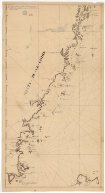
Map of the coast of China and part of Formosa Island between 2.d and 30.d 30.m north latitude
|
|
Original Title:
|
Carte de coste de la Chine et d'une partie de l'Isle Formose compris entre les 25.d et 30.d 30.m de latitude nord.
|
|
Category:
|
Sea Charts
|
|
Type:
|
Manuscripts
|
|
Language:
|
French
|
|
Create Year:
|
[16--]
|
|
Format:
|
JPEG 2000, 6792 × 12430, 142.2MB
|
|
Scale:
|
[ca. 1:580,000].
|
|
Physical Map Dimension (cm):
|
100 x 52 cm, on sheet 111 x 62 cm
|
|
Note:
|
This is a manuscript nautical chart of part of the East China Sea. It depicts the coastline of China with the northern part of the Island of Taiwan (Formosa) on the right lower corner. The chart is very detailed depicting the small islands and islets along the China coast. The soundings are given more abundantly around Taiwan and on the northeast part near Yandang Shan (Montagen de Lameau).
|
|
Note:
|
Original is a manuscript map, 104 x 56 cm.
|
|
Note:
|
There is a 4-point compass rose on the map with a fleur-de-lis indicating north and a cross on the East point. Another two fleur-de-lis indicate north.
|
|
Note:
|
Relief shown pictorially and bathymetric relief shown by soundings.
|
|
Note:
|
Latitude line on the left border of the map in black and white interchangeably.
|
|
Note:
|
Map with graticule.
|
|
Note:
|
Outlined in tiple fillet.
|
|
Geographic Area:
|
North Pacific Ocean
|
|
Geographic Area:
|
Zhejiang Sheng (China)
|
|
Geographic Area:
|
Zhoushan Archipelago (China)
|
|
Geographic Area:
|
Fujian Sheng (China)
|
|
Geographic Area:
|
Pingtan Xian (China)
|
|
Geographic Area:
|
Taiwan
|
|
Provenance:
|
Bibliothèque Nationale de France
|
|
Provenance:
|
https://catalogue.bnf.fr/ark:/12148/cb45085383c
|
|
Provenance Call No.:
|
GE SH 18 PF 179 DIV 3 P 4/1
|
|
MUST holding:
|
https://must.primo.exlibrisgroup.com/permalink/853MUST_INST/171sgkf/alma991003002049205076
|