Detail View: Old Maps Collection: 大清廣輿圖 = Carte de la Chine sous la dynastie Ts'ing
|
Barcode:
|
4687820501108
|
|
Title:
|
大清廣輿圖 = Carte de la Chine sous la dynastie Ts'ing
|
|
Original Title:
|
大清廣輿圖
|
|
Contributor:
|
Nagakubo, Sekisui, 1717-1801
|
|
Contributor:
|
程赤城
|
|
Contributor:
|
蔡方炳, 1626-1709
|
|
Category:
|
General Maps
|
|
Type:
|
Printed
|
|
Language:
|
Chinese
|
|
Create Year:
|
1785
|
|
Format:
|
JPEG2000, 23703 × 22518, 672.1MB
|
|
Scale:
|
Scale not given
|
|
Physical Map Dimension (cm):
|
188 x 179
|
|
Note:
|
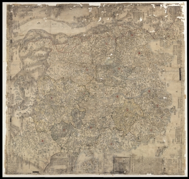
A rare and important Tenmei 5, Qianlong 50 or 1785 woodblock map of Qing Dynasty China printed in woodblock. This enormous Chinese language map covers from the Tibet and the Kunlun Mountains in western China to Taiwan and the East China Sea, and from Manchuria to Hainan. The map seems to be focus on transportation routes and identifies important roadways, bridges, and other trade arteries throughout. It also names historical sites and offers numerous annotations at points of cultural or historical interest. The Great Wall of China appears just north of Beijing. Interestingly, the map shows an alternate route for the Lower Yellow River, probably related to a course change associated with one of the frequently floods and notes that the dry river bed is a major travel route (黄河古道). This map was compiled and published in 1785, or Tenmei 5, or Qianlong 50 by the important Japanese mapmaker Nagakubo Sekisui (長久保玄珠) based upon the 1686 Qing Chinese atlas of Cai Fangbing (蔡方炳, also known as Cai Jiuxia 蔡九霞). Cai's information was updated extensively with new data collected by Sekisui in preparation for this map's publication.
|
|
Note:
|
Macao in China Maps
|
|
Geographic Area:
|
China
|
|
Provenance:
|
Bibliothèque nationale de France
|