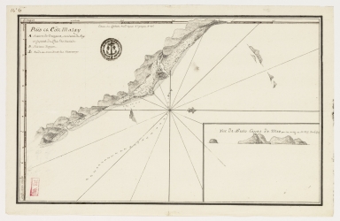
Detail View: Old Maps Collection: Païs et côte Malay

|
Barcode:
|
4687820501265
|
|
Title:
|
Païs et côte Malay
|
|
Other Title:
|
[Vues de cotes des mers de Chine], 8.e
|
|
Other Title:
|
Vue de Pulo Capas de Mer par sou milieu ou SE. 1ºº 1/2 S. 5 a 6 lieues.
|
|
Contributor:
|
Surville, Jean-François de, 1717-1770, cartographer
|
|
Category:
|
Sea Charts
|
|
Type:
|
Manuscripts
|
|
Language:
|
French
|
|
Create Year:
|
[17--]
|
|
Format:
|
JPEG 2000, 5929 × 3862, 26MB
|
|
Page No.:
|
6
|
|
Scale:
|
Scale indeterminable.
|
|
Physical Map Dimension (cm):
|
21 x 34 cm, on sheet 24 x 38 cm
|
|
Note:
|
This is the first sheet of a manuscript by Jean-François de Surville of the islands and islets of the many coasts on the China Sea. Surville was a Captain of the Compagnie des Indes, and set off on the 'St.-Jean Baptiste' to locate the points in the Pacific likely to be used by the French in trade or in a maritime war. This particular depicts a map of a part of the Malay coast, with an inset of a small island.
|
|
Note:
|
Inset 1: Vue de Pulo Capas de Mer par sou milieu ou SE. 1ºº 1/2 S. 5 a 6 lieues. - 9 x 13 cm.
|
|
Note:
|
Original is a manuscript watercolor of some islands and islets of the China Sea.
|
|
Note:
|
There is a 16-point compass rose on the map with a fleur de lis indicating north. Legend underneath the title.
|
|
Note:
|
Relief is shown pictorially and by land forms. Bathymetric relief shown by soundings.
|
|
Note:
|
Latitude line on the left side on the map and longitude line at the top. Both in black and white interchangeably.
|
|
Note:
|
Map and inset outlined in double fillet.
|
|
Subject:
|
China -- Maps
|
|
Geographic Area:
|
China Sea -- coasts
|
|
Geographic Area:
|
Malaysia -- coasts
|
|
Relation Note:
|
N.º 6.e
|
|
Pub Title:
|
Voyage de Surville.
|
|
Pub Author:
|
Surville, Jean-François de, 1717-1770
|
|
Pub Year:
|
[17--]
|
|
Provenance:
|
Bibliothèque Nationale de France
|
|
Provenance Call No.:
|
GE SH 18 PF 183 DIV 1 P 1 (PL 6)
|
|
MUST holding:
|
https://must.primo.exlibrisgroup.com/permalink/853MUST_INST/utvbn5/alma991002987649605076
|