Detail View: Old Maps Collection: Reduced map of the Chinese Sea : 1st or southern leaf. eng
|
Barcode:
|
3687800354274E
|
|
Title:
|
Reduced map of the Chinese Sea : 1st or southern leaf. eng
|
|
Original Title:
|
Reduzirte Karte vom Chinesischen Meere : 1.stes oder Südliches Blatt. Dem James Horsburgh ... dem gelehrten Beschreiber der Indischen Meere, durch dessen treffliche Arbeiten und freundschaftliche Privat-Mittheilungen der Entwurf der hydrographischen Blatter des Asiatisch. Atlases nur allein moglich wurde, - widmet die vorliegende Darstellung des Chinesischen Meeres aus innigster Verehrung und Dankbarkeit
|
|
Other Title:
|
Berghaus's Atlas von Asia
|
|
Other Title:
|
Golf von Siam und die Kuste von Kambodja, Tschampa
|
|
Contributor:
|
Jäck, Wilhelm, fl. 1834, engraver
|
|
Contributor:
|
Brose, Wilhelm, fl. 1834, engraver
|
|
Contributor:
|
Horsburgh, James, 1762-1836, dedicatee
|
|
Contributor:
|
Justus Perthes (Firm : Gotha, Germany), publisher
|
|
Category:
|
General Maps
|
|
Type:
|
Printed
|
|
Language:
|
German
|
|
Create Year:
|
1835
|
|
Format:
|
JPEG 2000, 15439 x 10567, 218.6MB
|
|
Page No.:
|
14
|
|
Scale:
|
[ca. 1:2,300,000].
|
|
Physical Map Dimension (cm):
|
62 x 88 cm, on sheet 72 x 112 cm
|
|
Note:
|
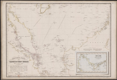
The map was published in the book 'Großer Atlas der Außereuropäischen Erdtheile' by Henrich Berghaus. He was a German geographer and cartographer, trained as a surveyor, who carried on a geographical school at Potsdam. Berghaus's written works were numerous and important. This particular map depicts the South China Sea with the Strait of Malacca, the south coast of Vietnam, and the northwest coast of the Borneo Island. Several routes are given. There are several soundings scattered on the map but more specifically on the Malacca Strait given its importance in the East India trade.
|
|
Note:
|
Inset 1: Golf von Siam und die Kuste von Kambodja, Tschampa : im halben Maasstab der Haupfkarte. - Scale indeterminable - 17 x 25 cm.
|
|
Note:
|
Original is a lithograph, 65 x 86 cm.
|
|
Note:
|
Underneath the title: "Gestochen von W. Jaeck u. W. Brose in Berlin." And on the left upper corner of the map: "Berghaus's Atlas von Asia".
|
|
Note:
|
Title of the main map and inset with scroll work elements.
|
|
Note:
|
Relief shown by hachures and bathymetric relief by soundings.
|
|
Note:
|
Land masses outlined in color.
|
|
Note:
|
The four borders of the main map and inset with latitude and longitude lines in black and white interchangeably.
|
|
Note:
|
Main map and inset with graticule.
|
|
Note:
|
Map and inset outlined in triple fillet.
|
|
Subject:
|
Administrative and political divisions
|
|
Geographic Area:
|
South China Sea
|
|
Geographic Area:
|
Cambodia
|
|
Geographic Area:
|
Vietnam
|
|
Geographic Area:
|
Malacca (Malacca, Malaysia)
|
|
Geographic Area:
|
Strait of Malacca
|
|
Geographic Area:
|
Singapore
|
|
Geographic Area:
|
Sumatra (Indonesia)
|
|
Geographic Area:
|
Borneo
|
|
Geographic Area:
|
Thailand
|
|
Geographic Area:
|
Gulf of Thailand
|
|
Relation Note:
|
N.º 14
|
|
Pub Title:
|
Großer Atlas der Außereuropäischen Erdtheile.
|
|
Pub Author:
|
Berghaus, Henrich, 1797-1884
|
|
Pub Year:
|
1832-1843
|
|
Pub location:
|
Gotha
|
|
Provenance:
|
Bibliothèque Nationale de France
|
|
Provenance:
|
https://catalogue.bnf.fr/ark:/12148/cb408826479
|
|
Provenance Call No.:
|
GE CC-863 (14)
|
|
MUST holding:
|
https://must.primo.exlibrisgroup.com/permalink/853MUST_INST/reglfj/alma991002989249705076
|