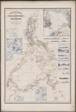
Detail View: Old Maps Collection: Reduced map of the Philippines and Susu Islands.
|
Barcode:
|
3687800354273D
|
|
Title:
|
Reduced map of the Philippines and Susu Islands.
|
|
Original Title:
|
Reduzirte Karte von den Philippinen und den Susu Inseln : den manen Don Alexandro's Malaspina und Don Espinosa y Tello's, so wie dem Ubersten Don Ildefonso de Aragon, Befehlshaber des Königl. Ingenieur-Korps auf den Philippinischen Inseln, einen Beweis der Anerkennung ihrer ausgezeichneten Verdienste um die Hydro und Geographie der Philippinen gewidmet.
|
|
Other Title:
|
Berghaus's Atlas von Asia
|
|
Other Title:
|
Islas Batanes.
|
|
Other Title:
|
Plan von der Butch von Manila.
|
|
Other Title:
|
Die Nordseite des Mindoro Kan : mit den Volcan de Taal.
|
|
Other Title:
|
Volcan de Taal.
|
|
Other Title:
|
Landsichten von Magindano und den Südöstlichen Inseln.
|
|
Other Title:
|
Bongo Bucht.
|
|
Other Title:
|
Der Hafen Tetyan von Innen.
|
|
Other Title:
|
Der Hafen Batulakki auf Mindanao.
|
|
Other Title:
|
Serangani Inseln.
|
|
Other Title:
|
Salibabo Inseln.
|
|
Other Title:
|
Kabruang aus dem Hafen Salibabo gesehen.
|
|
Other Title:
|
Insel Sangir.
|
|
Other Title:
|
Sulu Gebiet an der NW. Küste von Borneo.
|
|
Other Title:
|
Passage Inseln.
|
|
Other Title:
|
Südlicher Theil der Sûlûschen Borneo Küste.
|
|
Other Title:
|
Plan von der Bongo Bucht.
|
|
Other Title:
|
Ansicht von der westlichen Küste Luzon's von Latitudo 15º 40' bis 14º 50' N. 5 Seemeilen weit.
|
|
Other Title:
|
Ansicht der Isla de Cabras, 3 eemeilen Entfernung.
|
|
Other Title:
|
Ansicht der Insel Luban, auf 4 Seemeilen weit.
|
|
Other Title:
|
Ansicht von Mindanao's Süd-West-Ende in der Richtung von Süd gen Ost, bis O.S.O., 4 Seemeilen.
|
|
Other Title:
|
Batanische Inseln.
|
|
Contributor:
|
Siebert, Selmar, 1808-1885, engraver
|
|
Contributor:
|
Justus Perthes (Firm : Gotha, Germany), publisher
|
|
Contributor:
|
Malaspina, Alessandro, 1754-1809, dedicatee
|
|
Contributor:
|
Espinosa y Tello, José, 1763-1815, dedicatee
|
|
Contributor:
|
Aragón y Abollado, Ildefonso de, ca. 1760-ca. 1835, dedicatee
|
|
Category:
|
General Maps
|
|
Type:
|
Printed
|
|
Language:
|
German
|
|
Language:
|
Spanish
|
|
Language:
|
Portuguese
|
|
Create Year:
|
1832
|
|
Format:
|
JPEG 2000, 10603 x 15507, 230.6MB
|
|
Page No.:
|
13
|
|
Scale:
|
Scale not given.
|
|
Physical Map Dimension (cm):
|
84 x 58 cm, on sheet 112 x 72 cm
|
|
Note:
|
The map was published in the book 'Großer Atlas der Außereuropäischen Erdtheile' by Henrich Berghaus. He was a German geographer and cartographer, trained as a surveyor, who carried on a geographical school at Potsdam. Berghaus's written works were numerous and important. This particular map depicts the Philippines Islands and part of northeast Borneo with Celebes and Sulu Seas. To each Philippine Island it is given equal detail although most of the of the insets are of Manilla, Mindanao and the most important bays.
|
|
Note:
|
Inset 1: Islas Batanes. - Scale not given. - 7 x 6 cm. -- Inset 2: Plan von der Butch von Manila. - Scale not given. - 24 x 24 cm. -- Inset 3: Die Nordseite des Mindoro Kan : mit den Volcan de Taal. - Scale indeterminable. - 15 x 14 cm. - Volcan de Taal. - Scale not given. - 3 x 14 cm. -- Inset 4: Landsichten von Magindano und den Südöstlichen Inseln. - Scale not given. - 23 x 10 cm. - Bongo Bucht. - Scale not given. - 5 x 10 cm. - Der Hafen Tetyan von Innen. - Scale not given. - 5 x 10 cm. - Der Hafen Batulakki auf Mindanao. - Scale not given. - 2 x 10 cm. - Serangani Inseln. - Scale not given. - 2 x 10 cm. - Salibabo Inseln. - Scale not given. - 2 x 10 cm. - Kabruang aus dem Hafen Salibabo gesehen. - Scale not given. - 5 x 10 cm. - Insel Sangir. - Scale not given. - 2 x 10 cm. -- Inset 5: Sulu Gebiet an der NW. Küste von Borneo. - Scale not given. - 6 x 6 cm. -- Inset 6: Passage Inseln. - Scale not given. - 3 x 6 cm. -- Inset 7: Südlicher Theil der Sûlûschen Borneo Küste. - Scale not given. - 5 x 9 cm. -- Inset 8: Plan von der Bongo Bucht. - Scale indeterminable. - 12 x 10 cm.
|
|
Note:
|
Original is a lithograph, 99 x 66 cm.
|
|
Note:
|
Underneath the title: "Gest. v. Selmar Siebert". And on the left upper corner of the map: "Berghaus's Atlas von Asia".
|
|
Note:
|
There are 5 side views of the islands, coastlines, and shores: Ansicht von der westlichen Küste Luzon's von Latitudo 15º 40' bis 14º 50' N. 5 Seemeilen weit ; Ansicht der Isla de Cabras, 3 eemeilen Entfernung ; Ansicht der Insel Luban, auf 4 Seemeilen weit ; Ansicht von Mindanao's Süd-West-Ende in der Richtung von Süd gen Ost, bis O.S.O., 4 Seemeilen ; Batanische Inseln.
|
|
Note:
|
On inset 1 there is a 32-point compass rose with a fleur de lis indicating north. The rhumb lines for the principal winds are in simple fillet, the half-winds are blurred lines are for the quarter-winds dashed lines.
|
|
Note:
|
Title with scroll work elements.
|
|
Note:
|
Relief shown by hachures and land forms. Bathymetric relief by soundings.
|
|
Note:
|
Landmasses outlined in yellow, orange and green.
|
|
Note:
|
The four borders of the main map with latitude and longitude lines in black and white interchangeably.
|
|
Note:
|
Main map and insets 1, 5 and 7 with graticule.
|
|
Note:
|
Main map and inset 1 outlined in triple fillet, insets 3-4 and 6-8 in double fillet and insets 1 and 5 in simple bold fillet.
|
|
Subject:
|
Administrative and political divisions
|
|
Geographic Area:
|
Philippines
|
|
Geographic Area:
|
Manila Bay (Philippines)
|
|
Geographic Area:
|
Celebes Sea
|
|
Geographic Area:
|
Sulu Sea
|
|
Geographic Area:
|
Borneo
|
|
Relation Note:
|
N.º 13
|
|
Pub Title:
|
Großer Atlas der Außereuropäischen Erdtheile. G
|
|
Pub Author:
|
Berghaus, Henrich, 1797-1884
|
|
Pub Year:
|
1832-1843
|
|
Pub location:
|
Gotha
|
|
Provenance:
|
Bibliothèque Nationale de France
|
|
Provenance:
|
https://catalogue.bnf.fr/ark:/12148/cb40882646z
|
|
Provenance Call No.:
|
GE CC-863 (13)
|
|
MUST holding:
|
https://must.primo.exlibrisgroup.com/permalink/853MUST_INST/reglfj/alma991002988049705076
|