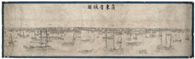
Detail View: Old Maps Collection: 廣東省城圖 = Plan du port de Canton
|
Barcode:
|
4687820501245
|
|
Title:
|
廣東省城圖 = Plan du port de Canton
|
|
Original Title:
|
廣東省城圖
|
|
Contributor:
|
Anonymous
|
|
Category:
|
City Plans & Views
|
|
Type:
|
Printed
|
|
Language:
|
Chinese
|
|
Create Year:
|
1718?
|
|
Format:
|
JPEG2000, 23945 x 7329, 256.3MB
|
|
Scale:
|
Scale not given
|
|
Physical Map Dimension (cm):
|
195 x 55
|
|
Geographic Area:
|
Guangzhou Shi (China)
|
|
Provenance:
|
Bibliothèque nationale de France
|