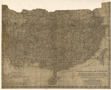
Detail View: Old Maps Collection: Carte generale de la Chine : dressée sur les cartes particulieres que l'Empereur Cang-hi a fait lever sur les lieux par les RR. PP. Jesuites mission[n]aires dans cet Empire
|
Barcode:
|
4687820501242
|
|
Title:
|
Carte generale de la Chine : dressée sur les cartes particulieres que l'Empereur Cang-hi a fait lever sur les lieux par les RR. PP. Jesuites mission[n]aires dans cet Empire
|
|
Contributor:
|
Anville, Jean Baptiste Bourguignon d', 1697-1782, cartographer
|
|
Category:
|
General Maps
|
|
Type:
|
Manuscripts
|
|
Language:
|
French
|
|
Create Year:
|
1730
|
|
Format:
|
JPEG2000, 6251 x 5100, 56.5MB
|
|
Scale:
|
Scale indeterminable.
|
|
Physical Map Dimension (cm):
|
41 x 51 cm, on sheet 46 x 111 cm
|
|
Note:
|
This is a manuscript added information by D'Anville made from a truncated engraving map from the book 'Description géographique, historique, chronologique, politique et physique de l'empire de la Chine et de la Tartarie chinoise' by he Jesuit Jean-Baptiste Du Halde (1674-1743 ), confessor to the king Louis XIV (1638-1715). The sources of the book by Du Halde were prepared by Jesuit missionaries commissioned by Emperor Kangxi (1654-1722), who between 1708 and 1716 surveyed China. With these surveys it was printed in 1719 the woodblock Chinese Atlas '康熙皇輿全覽圖' -a copperplate edition was requested by the Emperor to Matteo Ripa (1682-1746) and the copper plates exist to this day. The original map is much larger and encompasses all of China but this one was cut on the top part to include only the South of China with Taiwan and Hainan. The legend on the left bottom corner gives some information necessary for the understanding of the chart. Most information is about the Chinese and Portuguese language references on the map.
|
|
Note:
|
Original is a manuscript added information to a truncated engraving from the 'Description géographique, historique, chronologique, politique et physique de l'empire de la Chine et de la Tartarie chinoise' by Jean-Baptiste du Halde (1674-1743), from Chinese originals, 40 x 50 cm.
|
|
Note:
|
Triple scale line in Chinese lys, leagues and nautic leagues, in black and white interchangeably, underneath the title on the right bottom corner of the map.
|
|
Note:
|
Relief shown pictorially.
|
|
Note:
|
Map with graticule.
|
|
Note:
|
Three borders of the map -left, right and bottom- with latitude and longitude lines.
|
|
Note:
|
Map outlined in double fillet.
|
|
Note:
|
Macao in China maps.
|
|
Reference:
|
Destombes, M. Les Originaux Chinois des Plans de Ville publiés par J.-B. du Halde, p. 85-87
|
|
Reference:
|
Manne, L.C.J., Barbié Du Bocage, J.D. Notice des ouvrages de M. d'Anville, 139, p. 81
|
|
Reference:
|
Petto, C.M. When France was King of Cartography: The Patronage and Production of Maps in Early Modern France, 107, p. 95
|
|
Geographic Area:
|
China
|
|
Provenance:
|
Bibliothèque Nationale de France
|
|
Provenance:
|
https://catalogue.bnf.fr/ark:/12148/cb40772785r
|
|
Provenance Call No.:
|
GE D-10588
|
|
MUST holding:
|
https://must-primo.exlibris.com.cn/permalink/853MUST_INST/171sgkf/alma991002968746805076
|