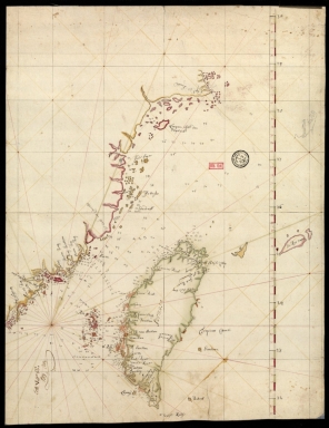
Detail View: Old Maps Collection: [Map of the southeast coast of China]
|
Barcode:
|
3687800354499N
|
|
Title:
|
[Map of the southeast coast of China]
|
|
Category:
|
Sea Charts
|
|
Type:
|
Manuscripts
|
|
Language:
|
English
|
|
Language:
|
Latin
|
|
Create Year:
|
[17--]
|
|
Format:
|
JPEG 2000, 5375 x 6964, 62.8MB
|
|
Scale:
|
Scale not given.
|
|
Physical Map Dimension (cm):
|
29 x 22 cm, on sheet 35 x 28 cm
|
|
Note:
|
This is a nautical chart of a part of the Southeast coast of China with the Island of Taiwan (Formosa). Characteristic of nautical charts the map focus on waterways and inshore areas, and so quite a number of soundings are given as well as some inshore toponyms while the interior remains mostly blank. The soundings are especially concentrated on the Taiwan Strait and around the Penghu islands as the east coast of Taiwan remains mostly blank, the same is true for toponyms on the island. Most of the toponyms are in English which may denote an English author of the chart.
|
|
Note:
|
Original is a manuscript nautical chart.
|
|
Note:
|
The coast lines of continents and bigger islands are outlined in yellow, green and magenta and smaller islands are painted with the same colors.
|
|
Note:
|
Latitude line on the right side of the chart in green and magenta interchangeably.
|
|
Note:
|
Tropic of Cancer with double line.
|
|
Note:
|
Relief shown pictorially and bathymetric relief by soundings.
|
|
Note:
|
Map with grid.
|
|
Note:
|
Place names in English with Tropic of Cancer in Latin.
|
|
Subject:
|
Waterways
|
|
Subject:
|
Coasts
|
|
Geographic Area:
|
Zhejiang Sheng (China)
|
|
Geographic Area:
|
Fujian Sheng (China)
|
|
Geographic Area:
|
Taiwan
|
|
Provenance:
|
Bibliothèque Nationale de France
|
|
Provenance Call No.:
|
SH 18 PF 181 P 16 D
|
|
MUST holding:
|
https://must.primo.exlibrisgroup.com/permalink/853MUST_INST/171sgkf/alma991003001949805076
|