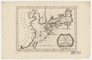
Detail View: Old Maps Collection: Carte des isles du Japon et la presqu'isle de Coree, avec les costes de la Chine depuis Pekin jusqu'a Canton = Kaart van de Eilanden van Japan, en van't Half-Eiland Koréa ; met de Kusten van China van Pekin tot Canton
|
Barcode:
|
4687820500209
|
|
Title:
|
Carte des isles du Japon et la presqu'isle de Coree, avec les costes de la Chine depuis Pekin jusqu'a Canton = Kaart van de Eilanden van Japan, en van't Half-Eiland Koréa ; met de Kusten van China van Pekin tot Canton
|
|
Original Title:
|
Carte des isles du Japon et la presqu'isle de Coree, avec les costes de la Chine depuis Pekin jusqu'a Canton = Kaart van de Eilanden van Japan, en van't Half-Eiland Koréa ; met de Kusten van China van Pekin tot Canton
|
|
Contributor:
|
Bellin, Jacques Nicolas, 1703-1772
|
|
Contributor:
|
Schley, Jacobus van der, 1715-1779
|
|
Category:
|
Sea Charts
|
|
Type:
|
Printed
|
|
Language:
|
French
|
|
Create Year:
|
1747
|
|
Format:
|
JPEG, 10362 × 6792, 63.9MB
|
|
Scale:
|
[ca. 1:11,250,000]
|
|
Physical Map Dimension (cm):
|
20 × 27
|
|
Note:
|
Map showing the islands of Japan, the Korean peninsula and the coast of China. "Par N. Bellin Ing.r de la Marine. J. V. Schley direx."
|
|
Note:
|
Macao and the surrounding islands were depicted in this map.
|
|
Note:
|
This map presents the eastern coast of China, Taiwan, Korea and Japan. Guangzhou and Macao were the only annotated cities within the Guangdong region, while Macao was labelled as ‘Makao’ instead of the traditional name of ‘Macao’.
|
|
Note:
|
Macao in Asia Maps
|
|
Subject:
|
Nautical charts
|
|
Geographic Area:
|
Japan
|
|
Geographic Area:
|
Korea
|
|
Geographic Area:
|
China
|
|
Relation Note:
|
Appears in: Prevost, Antoine-François "Histoire general de Voyages..". Hague, Pierre de Hondt, 1747-67. 21 vols. (v. 2, p. 372)
|
|
Pub Title:
|
L’Histoire générale des voyages
|
|
Pub Author:
|
Prévost, abbé, 1697-1763
|
|
Pub Year:
|
[1749]
|
|
Pub location:
|
[Hague]
|
|
Provenance:
|
Harvard Map Collection - Harvard College Library
|