Detail View: Old Maps Collection: Map of China, and a description of the work of missionaries in China
|
Barcode:
|
4687820501236
|
|
Title:
|
Map of China, and a description of the work of missionaries in China
|
|
Original Title:
|
Regni Sinae vel Sinae propriae mappa et descriptio geographica : ex mappis particularibus, quas Sinarum rex Canghi opera patrum missionariorum é S.I. in provincias regni universi ejus rei gratia ablegatorum concinnari fecit, perfecta, publicoque primum communicata in opere magnificentissimo R.P. Du Halde, et ab Anvillaeo Gall. Reg. geographo, in compendiosiorem hanc formam reducta, nunc secundum magis legitimas projectionis stereographicae leges reformata
|
|
Other Title:
|
Sinae propriae mappa et descriptio geographica
|
|
Contributor:
|
Hase, Johann Matthias, 1684-1742, author
|
|
Contributor:
|
Anville, Jean Baptiste Bourguignon d', 1697-1782, bibliographic antecedent
|
|
Contributor:
|
Homann Erben (Firm), printer
|
|
Category:
|
General Maps
|
|
Type:
|
Printed
|
|
Language:
|
Latin
|
|
Create Year:
|
[ca. 1738]
|
|
Format:
|
JPEG 2000, 6459 × 7201, 67.7MB
|
|
Scale:
|
[ca. 1:5,000,000].
|
|
Physical Map Dimension (cm):
|
58 x 52 cm, on sheet 72 x 60 cm
|
|
Note:
|
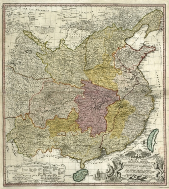
The map was made from the China map by Jean Baptiste Anville 'Carte generale de la Chine : dressée sur les cartes particulieres que l'Empereur Cang-hi a fait lever sur les lieux par les RR. PP. Jesuites mission[n]aires dans cet Empire'. The sources of Anville's map were Jesuit missionaries commissioned by Emperor Kangxi (1654-1722), who between 1708 and 1716 surveyed China. With these surveys it was printed in 1719 a woodblock Chinese Atlas '康熙皇輿全覽圖'. A copperplate edition was later requested by the Emperor to Matteo Ripa (1682-1746) and the copper plates exist to this day. The map includes China with Taiwan and Hainan. The explanation on the left bottom corner gives some information necessary for the understanding of the chart, most of it is about the Chinese language references on the map.
|
|
Note:
|
Original is a copperplate printed, colored by hand, 59 x 53 cm.
|
|
Note:
|
Ornamented scrollwork cartouche on the bottom right corner of the map sided by mandarin heads and dragons.
|
|
Note:
|
Four scale lines in black and white interchangeably, underneath the legend cartouche on the left bottom corner of the map.
|
|
Note:
|
Prime meridians: Peking and Nuremberg.
|
|
Note:
|
Different administrative regions outlined in different colors with the islands of Taiwan and Hainan colored blue.
|
|
Note:
|
Relief shown pictorially.
|
|
Note:
|
The four borders of the map with latitude and longitude lines in black and white interchangeably.
|
|
Note:
|
Map outlined in double fillet.
|
|
Note:
|
Macao in China Maps.
|
|
Subject:
|
Administrative and political divisions
|
|
Geographic Area:
|
China
|
|
Geographic Area:
|
Taiwan
|
|
Geographic Area:
|
Hainan Sheng (China)
|
|
Relation Note:
|
Tome XIV
|
|
Pub Title:
|
Atlas Geographique Contenant Les Cartes générales et particulières d'Asie, d'Affrique et d'Amérique.
|
|
Pub Year:
|
1749
|
|
Pub location:
|
Paris
|
|
Provenance:
|
Bibliothèque Nationale de France
|
|
Provenance:
|
https://catalogue.bnf.fr/ark:/12148/cb40606534n
|
|
Provenance Call No.:
|
GE BB-565 (14, 17)
|
|
MUST holding:
|
https://must.primo.exlibrisgroup.com/permalink/853MUST_INST/135m6n2/alma991002988049005076
|