Detail View: Old Maps Collection: Plan de la Riviere de Canton en Chine
|
Barcode:
|
36878003541237
|
|
Title:
|
Plan de la Riviere de Canton en Chine
|
|
Other Title:
|
Plan de la baye qui est a la point du sud de l'isle Satchuen, ou S.an Le Solide a mouillé.
|
|
Category:
|
Sea Charts
|
|
Type:
|
Manuscripts
|
|
Language:
|
French
|
|
Create Year:
|
[1711]-[1712]
|
|
Format:
|
JPEG 2000, 8952 × 6736, 47.9MB
|
|
Scale:
|
Scale not given.
|
|
Physical Map Dimension (cm):
|
53 x 70 cm, on sheet 62 x 79 cm
|
|
Note:
|
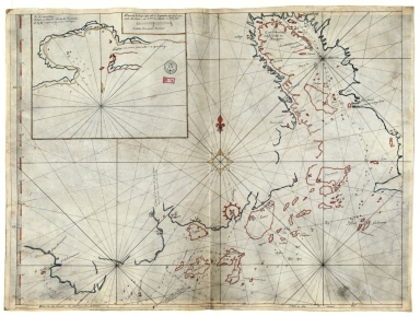
This nautical chart depicts the area of Guangzhou (Canton), the mouth of the Pearl River, Macau and the coast to the along Zhuhai (Quahhay). The navigational use of the map is made clear by the number of soundings indications, specially in approaching Zhuhai that is marked with a drawing of a fort colored red. Another landmarks are present on the map such as military, economic installations and buildings in general. that can be used as landmarks. The inset depicts the bay of the anchorage of the ship 'Le Solide' on the island of Xiachuandao (Satchuen). On the map it is also depicted the course of the ship 'Le Solid', ordered by Guillaume de Raguienne de Mareuil (16---17--), along the coast of Guangzhou, as well as in the inset, the island and the bay where the sailors established their camp. The toponyms on the map have a strong Portuguese trace.
|
|
Note:
|
Inset 1: Plan de la baye qui est a la point du sud de l'isle Satchuen, ou S.an Le Solide a mouillé. - Scale indeterminable. - 22 x 28 cm.
|
|
Note:
|
Original is a manuscript map, 54 x 73 cm.
|
|
Note:
|
There is an 8-point compass rose on the middle of the main map with a fleur-de-lis indicating north, colored yellow and red. On the inset there is a half fleur-de-lis indicating north, colored yellow. Title and scale line of the inset inside double fillet colored yellow.
|
|
Note:
|
Scale line of the main map on the right bottom part. Scale line on the inset underneath its title.
|
|
Note:
|
Latitude line on the left border of the map in red and white interchangeably.
|
|
Note:
|
Relief shown pictorially and bathymetric relief by soundings.
|
|
Note:
|
Landmasses outlined in blue and red.
|
|
Note:
|
Main map outlined in simple fillet and inset outlined in double fillet colored yellow.
|
|
Note:
|
Macao and its surroundings.
|
|
Reference:
|
Foncin, M. Catalogue des cartes nautiques sur vélin conservées au Département des cartes et plans , p. 296
|
|
Reference:
|
Pflederer, R. Census of Portolan Charts & Atlases: as reported and listed by the noted scholars of the genre in their works ranging from 1897 to 2008, p. 69
|
|
Subject:
|
Nautical charts
|
|
Geographic Area:
|
Pearl River (China)
|
|
Geographic Area:
|
Guangdong Sheng (China)
|
|
Geographic Area:
|
Macao (China)
|
|
Geographic Area:
|
South China Sea
|
|
Provenance:
|
Bibliothèque Nationale de France
|
|
Provenance:
|
https://catalogue.bnf.fr/ark:/12148/cb407817982
|
|
Provenance Call No.:
|
GE SH 18 PF 179 DIV 9 P 3 RES
|
|
MUST holding:
|
https://must.primo.exlibrisgroup.com/permalink/853MUST_INST/171sgkf/alma991002923849105076
|