Detail View: Old Maps Collection: Plan de la riviere de Canton, Macao, et autres isles circonvoisines
|
Barcode:
|
36878003541248
|
|
Title:
|
Plan de la riviere de Canton, Macao, et autres isles circonvoisines
|
|
Original Title:
|
Plan de la riviere de Canton, Macao, et avtres isles circonvoisines
|
|
Contributor:
|
Liébaut, 16---17--, catographer
|
|
Category:
|
Sea Charts
|
|
Type:
|
Manuscripts
|
|
Language:
|
French
|
|
Create Year:
|
1736
|
|
Format:
|
JPEG 2000, 6182 × 8018, 24.9MB
|
|
Scale:
|
[ca. 1:372,500].
|
|
Physical Map Dimension (cm):
|
60 x 45 cm, on sheet 63 x 48 cm
|
|
Note:
|
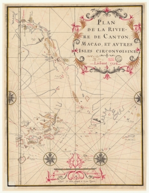
This is a manuscript nautical chart of the Pearl River. On the left upper corner of the map, near Canton, are depicted 3 towers. The first tower -underneath the representation of the city of Canton- identified as 'Tour d'amour' is the Chigang Pagoda -赤岗塔- or Red Stone Hill Pagoda. The pagoda was built in 1619 in an octagonal shape, it stands 53.7m tall with nine exterior floor sections and 17 interior levels. The second one -to the right of Canton- is 'Tour de Wampoü' also known as Pazhou Pagoda -琶洲塔- it is however misplaced as it should be in the Pazhou Island. It was built in 1600 with nine main sections and 17 sub sections with 59m high. The last one is 'Tour du Lion', the Lotus Pagoda -莲花塔- or Wenchang Pagoda built in 1612, a 8-corner brick-build architecture, 50m high, with nine floors outside and 11 layers inside. This three pagodas built at the mouth of the Pearl River are said to bring good luck to Guangzhou and the surrounding area.
|
|
Note:
|
Original is a manuscript map, 63 x 48 cm, on sheet 66 x 51 cm.
|
|
Note:
|
Title of the map, author and date at the right upper corner of the map in a scrollwork cartouche in black, magenta and yellow.
|
|
Note:
|
There are four 32-point compass roses on the map, two full and two half. All have a fleur-de-lis indicating north and are inside a yellow circumference. The rhumb lines for principal and quarter-winds in black and half-winds in magenta.
|
|
Note:
|
Scale line in black and magenta interchangeably at the bottom of the map in scrollwork cartouche.
|
|
Note:
|
Latitude line on the left side of the map.
|
|
Note:
|
Bathymetric relief shown by soundings and scarce pictorially relief on land.
|
|
Note:
|
Map outlined in double fillet black and yellow.
|
|
Note:
|
Macao and its surroundings.
|
|
Subject:
|
Waterways
|
|
Subject:
|
Coasts
|
|
Geographic Area:
|
China
|
|
Geographic Area:
|
Guangdong Sheng (China)
|
|
Geographic Area:
|
Pearl River Estuary (China)
|
|
Geographic Area:
|
Macao (China)
|
|
Provenance:
|
Bibliothèque Nationale de France
|
|
Provenance:
|
https://catalogue.bnf.fr/ark:/12148/cb450558954
|
|
Provenance Call No.:
|
GE SH 18 PF 179 DIV 9 P 8 D
|
|
MUST holding:
|
https://must.primo.exlibrisgroup.com/permalink/853MUST_INST/1dp55m9/alma991002923847705076
|