Detail View: Old Maps Collection: Plan de la riviere de Canton depuis la bouche du Tigre, jusqu'à Wampou
|
Barcode:
|
3687800354126A
|
|
Title:
|
Plan de la riviere de Canton depuis la bouche du Tigre, jusqu'à Wampou
|
|
Contributor:
|
Huddart, Joseph, 1741-1816, cartographer
|
|
Category:
|
General Maps
|
|
Type:
|
Manuscripts
|
|
Language:
|
French
|
|
Create Year:
|
1787
|
|
Format:
|
JPEG 2000, 6668 × 8748, 23MB
|
|
Scale:
|
[ca. 1:98,000].
|
|
Physical Map Dimension (cm):
|
58 x 43 cm, on sheet 60 x 47 cm
|
|
Note:
|
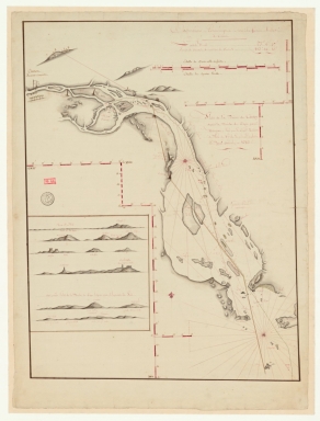
On the left upper corner of the map there is Canton with a representation of the European factories as the legend states. The map depicts the routes in the Pearl River. For navigational reference there are depicted four towers on the map. The first tower -right to the representation of the city of Canton- identified as 'Tour d'amour' is the Chigang Pagoda -赤岗塔- or Red Stone Hill Pagoda. The pagoda was built in 1619 in an octagonal shape, it stands 53.7 m tall with nine exterior floor sections and 17 interior levels. The second one -on the 'Wampou' island- is Pazhou Pagoda -琶洲塔- built in 1600 with nine main sections and 17 sub sections with 59 m high. The third one named 'Seichéet Pagoda de la 2.de barre' is most probably the Lotus Pagoda -莲花塔- or Wenchang Pagoda built in 1612, a 8-corner brick-build architecture, 50 m high, with nine floors outside and 11 layers inside. This three pagodas built at the mouth of the Pearl River are said to bring good luck to Guangzhou and the surrounding area. There is another pagoda represented on the map named 'Sechetow' -really close to the Lotus Pagoda- that couldn't be identified.
|
|
Note:
|
Original is a manuscript map, 63 x 48 cm, on sheet 72 x 54 cm.
|
|
Note:
|
Fleur-de-lis indicating north in red.
|
|
Note:
|
Double scale line in red and white interchangeably.
|
|
Note:
|
Several latitude and longitude lines in red and white interchangeably.
|
|
Note:
|
Relief is shown pictorially and by shading. Bathymetric relief is shown by soundings.
|
|
Note:
|
Map outlined in simple fillet with inset outlined in double fillet.
|
|
Geographic Area:
|
Pearl River Estuary (China)
|
|
Geographic Area:
|
Pazhou Island (Guangzhou Shi, China)
|
|
Provenance:
|
Bibliothèque Nationale de France
|
|
Provenance:
|
https://catalogue.bnf.fr/ark:/12148/cb450810660
|
|
Provenance Call No.:
|
GE SH 18 PF 179 DIV 10 P 3/2 D
|
|
MUST holding:
|
https://must.primo.exlibrisgroup.com/permalink/853MUST_INST/reglfj/alma991002923847605076
|