Detail View: Old Maps Collection: Carte des isles qui sont a l'embouchure de la riviere de Canton : dressée sur les observations des navigateurs = Kaart van de eilanden aan der mond der riviere van Kanton
|
Barcode:
|
4687820500205
|
|
Title:
|
Carte des isles qui sont a l'embouchure de la riviere de Canton : dressée sur les observations des navigateurs = Kaart van de eilanden aan der mond der riviere van Kanton
|
|
Original Title:
|
Carte des isles qui sont a l’embouchure de la riviere de Canton : dressée sur les observations des navigateurs = Kaart van de eilanden aan der mond der riviere van Kanton
|
|
Contributor:
|
Bellin, Jacques Nicolas, 1703-1772
|
|
Contributor:
|
Schley, Jacobus van der, 1715-1779
|
|
Category:
|
Sea Charts
|
|
Type:
|
Printed
|
|
Language:
|
French
|
|
Create Year:
|
1749
|
|
Format:
|
JPEG, 10564 × 6735, 65.6MB
|
|
Scale:
|
Scale not given
|
|
Physical Map Dimension (cm):
|
21 x 33
|
|
Note:
|
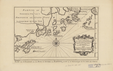
Shows the mouth of the Canton River and the islands off the coast of Kwangtung Province.
|
|
Note:
|
The map was drawn by Jacques Nicolas Bellin who was the French naval hydrologist and chief cartographer.
|
|
Note:
|
The map described the coastline and islands leading to the entrance to the Canton or Pearl River in southern ChinaMacao was marked in a ship channel from the entrance to Canton, I, Caolan(Gaolan Island), I.Nicou-ko (Hebao Island) ,Shang-chwen Shan(Shangchuan Island) was and the macao surrounding islands were depicted in this map.
|
|
Note:
|
Macao and its Surroundings
|
|
Geographic Area:
|
Macao (China)
|
|
Geographic Area:
|
Pearl River (China)
|
|
Relation Note:
|
From Antoine François Prévost’s "L’Histoire générale des voyages". Hague : Pierre de Hondt, 1747-1767. 21 vols. (v.7, p. 448).
|
|
Pub Title:
|
L’Histoire générale des voyages
|
|
Pub Author:
|
Prévost, abbé, 1697-1763.
|
|
Pub Year:
|
[1749]
|
|
Pub location:
|
[Hague]
|
|
Provenance:
|
Harvard Map Collection - Harvard College Library
|
|
MUST holding:
|
http://10.20.100.239/record=b1388955
|