Detail View: Old Maps Collection: [Carte française de la Mer de Chine et du Golfe de Siam]
|
Barcode:
|
36878003545017
|
|
Title:
|
[Carte française de la Mer de Chine et du Golfe de Siam]
|
|
Category:
|
Sea Charts
|
|
Type:
|
Manuscripts
|
|
Language:
|
French
|
|
Language:
|
Portuguese
|
|
Create Year:
|
[16--]-[17--]
|
|
Format:
|
JPEG 2000, 9320 × 6744, 51.1MB
|
|
Scale:
|
Scale not given.
|
|
Physical Map Dimension (cm):
|
71 x 53 cm, on sheet 78 x 48 cm
|
|
Note:
|
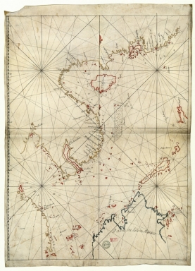
This is a sea chart of the South China Sea, Gulf of Thailand and Sulu Sea. The map is bordered on the west by the Mainland from 'Churasu' northeast of Guangzhou (Canton) to the tip of the Malay Peninsula and on the east by the islands of Borneo, Palawan (Isle de Pargoa), Calamian (I. de Colimines) and Luzon (Luçon). The coastline at the bottom of the Gulf of Thailand appears interrupted. Characteristic of nautical charts the map has most toponyms in inshore areas with the interior mainly blank and with a number of soundings given, specially near the coast and around islands and islets. Even though this chart seems to be from the end of the 17th century and beginning of the 18th the number of toponyms is quite scarce and the place name Macau is even missing on this chart. However, the Paracels are already depicted with the triangle, here named 'Lunettes' on its northeast corner.
|
|
Note:
|
Original is a manuscript nautical chart in parchment, 75 x 54 cm.
|
|
Note:
|
Title from provenance library.
|
|
Note:
|
There is a half fleur-de-lis indicating north. Rhumb lines for the principal winds in bold lines, for the half-winds in simple lines and for the quarter-winds in dotted lines.
|
|
Note:
|
Landmasses and bigger islands outlined in yellow, red and blue with small islands colored red.
|
|
Note:
|
Bathymetric relief given by soundings.
|
|
Note:
|
Map with grid.
|
|
Note:
|
Latitude line on the left border of the map in blue and white interchangeably.
|
|
Note:
|
Map outlined in simple fillet.
|
|
Note:
|
Most place names are in French but some can be found in Portuguese.
|
|
Reference:
|
Foncin, M. Catalogue des cartes nautiques sur vélin conservées au Département des cartes et plans, p. 297
|
|
Reference:
|
Pflederer, R.L. Census of Portolan Charts & Atlases: as reported and listed by the noted scholars of the genre in their works ranging from 1897 to 2008, p. 70
|
|
Subject:
|
Coasts
|
|
Geographic Area:
|
Southeast Asia
|
|
Geographic Area:
|
China
|
|
Geographic Area:
|
Thailand
|
|
Geographic Area:
|
Hainan Island (China)
|
|
Geographic Area:
|
Vietnam
|
|
Geographic Area:
|
Paracel Islands
|
|
Geographic Area:
|
Malaysia
|
|
Geographic Area:
|
Borneo
|
|
Geographic Area:
|
Philippines
|
|
Provenance:
|
Bibliothèque Nationale de France
|
|
Provenance:
|
https://catalogue.bnf.fr/ark:/12148/cb40781902r
|
|
Provenance Call No.:
|
GE SH 18 PF 181 P 9 RES
|
|
MUST holding:
|
https://must.primo.exlibrisgroup.com/permalink/853MUST_INST/171sgkf/alma991003001949705076
|