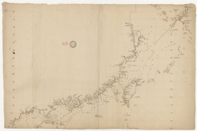
Detail View: Old Maps Collection: [Carte côtes de la Chine]

|
Barcode:
|
4687820501195
|
|
Title:
|
[Carte côtes de la Chine]
|
|
Category:
|
General Maps
|
|
Type:
|
Manuscripts
|
|
Language:
|
French
|
|
Create Year:
|
[17--]
|
|
Format:
|
JPEG 2000, 11277 × 7526, 14.7MB
|
|
Scale:
|
Scale not given.
|
|
Physical Map Dimension (cm):
|
65 x 98 cm, on sheet 79 x 112 cm
|
|
Note:
|
This is a sea chart of the East China Sea with the depths of the water-body in soundings. It depicts the coast of China, half of the Hainan Island, Taiwan, Korea and west side of Japan. The unknown author kept some degree of detail on land if it was important for navigation orientation. On the Hainan Island we can see the Portuguese word 'cidade' written, meaning there is a city at that place. Still in Hainan there is a 'Tour Blanche' that most probably is the Doubing Pagoda -斗柄塔- built in 1625 as a tower for navigation due to many shipwrecks although superstitious locals believed that these were actually caused by demons haunting the area. On the Leizhou Peninsula there is another tower named 'Haute Tour' which may refer to Dengyunta -登云塔- built in 1623, with 36.4 m can be seen from the sea.
|
|
Note:
|
Original is a manuscript map, 92 x 122 cm.
|
|
Note:
|
Bathymetric relief given by soundings.
|
|
Note:
|
Map with graticule.
|
|
Note:
|
Latitude on both sides of the map.
|
|
Note:
|
Macao in China maps.
|
|
Subject:
|
Waterways
|
|
Subject:
|
Coasts
|
|
Geographic Area:
|
China
|
|
Geographic Area:
|
East China Sea
|
|
Geographic Area:
|
Hainan Sheng (China)
|
|
Geographic Area:
|
Taiwan
|
|
Geographic Area:
|
Japan
|
|
Geographic Area:
|
Korea
|
|
Provenance:
|
Bibliothèque Nationale de France
|
|
Provenance Call No.:
|
GE SH 18 PF 181 P 12 D Carte côtes de la Chine
|
|
MUST holding:
|
https://must.primo.exlibrisgroup.com/permalink/853MUST_INST/171sgkf/alma991002932749505076
|