Detail View: Old Maps Collection: Chart of the seas of Canton to Cambodia and the Philippines
|
Barcode:
|
3687800354259H
|
|
Title:
|
Chart of the seas of Canton to Cambodia and the Philippines
|
|
Original Title:
|
[Carte des mers de Canton à Cambodge et aux Philippines]
|
|
Category:
|
General Maps
|
|
Type:
|
Manuscripts
|
|
Language:
|
French
|
|
Create Year:
|
[17--]
|
|
Format:
|
JPEG 2000, 13330 x 10383, 33.3MB
|
|
Scale:
|
Scale not given.
|
|
Physical Map Dimension (cm):
|
61 x 80 cm, on sheet 70 x 90 cm
|
|
Note:
|
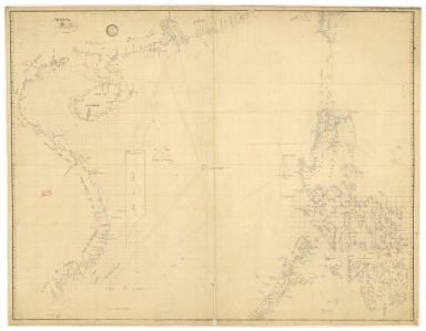
This chart depicts the South China Sea with the coasts of Vietnam and China, including the Paracel Islands, the Philippines and the south tip of Taiwan. Made most likely as a navigational aid chart it displays some soundings with place names along the coast lines with inland areas mostly kept blank. The Paracel bank is already accompanied by the triangular set on its northeast side with the designation 'Les Lunette ou Le Cordon de S.t Anthoine'. On the map routes are marked in red lines and some of them are connected to Macau, that is marked on Xiangshan rather than only on the Macau Peninsula.
|
|
Note:
|
Original is a manuscript map.
|
|
Note:
|
Title from provenance library.
|
|
Note:
|
Bathymetric relief given by soundings.
|
|
Note:
|
Map with grid.
|
|
Note:
|
Latitude lines on both sides of the map.
|
|
Note:
|
Map outlined in simple bold fillet.
|
|
Note:
|
Macao in Asia maps.
|
|
Note:
|
Macao in routes.
|
|
Subject:
|
Chart
|
|
Geographic Area:
|
South China Sea
|
|
Geographic Area:
|
Cambodia
|
|
Geographic Area:
|
Philippines
|
|
Geographic Area:
|
Vietnam
|
|
Geographic Area:
|
China
|
|
Geographic Area:
|
Hainan Sheng (China)
|
|
Geographic Area:
|
Taiwan
|
|
Geographic Area:
|
Paracel Islands
|
|
Provenance:
|
Bibliothèque Nationale de France
|
|
Provenance Call No.:
|
GE SH 18 PF 181 P 24
|
|
MUST holding:
|
https://must.primo.exlibrisgroup.com/permalink/853MUST_INST/171sgkf/alma991002988049805076
|