Detail View: Old Maps Collection: [Carte des Mers de Java jusqu'à Canton]
|
Barcode:
|
4687820501190
|
|
Title:
|
[Carte des Mers de Java jusqu'à Canton]
|
|
Other Title:
|
[Carte depui l'entrée du detrou de la Sonde jusqu'a Canton]
|
|
Contributor:
|
Robert
|
|
Category:
|
Sea Charts
|
|
Type:
|
Manuscripts
|
|
Language:
|
French
|
|
Create Year:
|
1720
|
|
Format:
|
JPEG 2000, 12611 × 19949, 41MB
|
|
Scale:
|
Scale not given.
|
|
Physical Map Dimension (cm):
|
120 x 74 cm, on sheet 130 x 112 cm
|
|
Note:
|
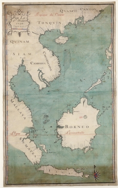
Original map is manuscript watercolored on parchment 124 x 76.5 cm. The back of the map has a manuscript note 'Carte depui l'entrée du detrou de la Sonde jusqu'a Canton' and 'Porte.lle - 181, Pièce - 19'.
|
|
Note:
|
Title of the map from the provenance library.
|
|
Note:
|
The nautical chart has a red and blue semi compass rose indicating north. Latitude is depicted on both sides, watercolor interchangeably red and blue. The eight half-winds rhumb lines are drawn in red as is the Equinox line and Tropic of Cancer.
|
|
Note:
|
The scrollwork on the upper left side has written 'Par le S.r Robert, 1720. Echelle de 60 L.a' and the scale line is interchangeably red and blue.
|
|
Note:
|
Map outlined in simple fillet.
|
|
Note:
|
Macao in East Indies Maps.
|
|
Reference:
|
Foncin, M. Catalogue des Cartes Nautiques sur Vélin: Conservées au Département des Cartes et Plans, p. 297
|
|
Reference:
|
Pflederer, R.L. Census of Portolan Charts & Atlases, p. 69
|
|
Geographic Area:
|
South China Sea
|
|
Geographic Area:
|
Southeast Asia
|
|
Geographic Area:
|
Indonesia
|
|
Geographic Area:
|
Borneo
|
|
Geographic Area:
|
Paracel Islands
|
|
Provenance:
|
Bibliothèque Nationale de France
|
|
Provenance:
|
https://catalogue.bnf.fr/ark:/12148/cb407819064
|
|
Provenance Call No.:
|
GE SH 18 PF 181 P 19 RES
|
|
MUST holding:
|
https://must.primo.exlibrisgroup.com/permalink/853MUST_INST/171sgkf/alma991000811699705076
|