Detail View: Old Maps Collection: Map of the China Sea
|
Barcode:
|
3687800354506C
|
|
Title:
|
Map of the China Sea
|
|
Original Title:
|
[Carte de la Mer de Chine]
|
|
Other Title:
|
Carte en hollandois des costes depuis Malacca jusques a Nangking avec le Jappon, Philippines & c.a
|
|
Other Title:
|
From Mallacca to Japan
|
|
Contributor:
|
Blaeu, Joan, 1596-1673, cartographer
|
|
Category:
|
Sea Charts
|
|
Type:
|
Manuscripts
|
|
Language:
|
Dutch
|
|
Language:
|
Portuguese
|
|
Language:
|
Spanish
|
|
Language:
|
Latin
|
|
Create Year:
|
1666
|
|
Format:
|
JPEG 2000, 15407 × 12893, 35MB
|
|
Scale:
|
Scale indeterminable.
|
|
Physical Map Dimension (cm):
|
79 x 94 cm, on sheet 87 x 111 cm
|
|
Note:
|
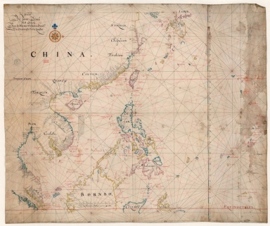
This Portolan chart is typical of the Dutch cartography of the 17th century with Portuguese influence. On it are depicted the Western Pacific, China and Philippine Seas, as for the coast line extends from Malaysia to Nanjing with Korea (Coraij) represented as a small island. The other islands present are the Chinese islands of Hainan and Taiwan, a small part of Sumatra, the north part of Borneo and Philippines and southeast Japan. Near the coast of the Vietnamese East coast are the Paracels in the Vaz Dourado type, although with the triangular set on its northeast side that started to emerge on Dutch maps by the mid-16th century.
|
|
Note:
|
Original is a manuscript chart on parchment, 79 x 95 cm. With the manuscript titles on the back "Carte en hollandois des costes depuis Malacca jusques a Nangking avec le Jappon, Philippines & c.a" and "From Mallacca to Japan".
|
|
Note:
|
Title from provenance library.
|
|
Note:
|
There is one 32-point scale line on the map with a fleur-de-lis indicating north and a cross on the East point. It is colored yellow, blue and red with rhumb lines for the principal winds in black, half-winds in green and quarter-winds in red.
|
|
Note:
|
Table of leagues in the center bottom of the map.
|
|
Note:
|
Relief shown pictorially.
|
|
Note:
|
Latitude line on the right edge of the map in blue, yellow and magenta interchangeably.
|
|
Note:
|
Tropic of Cancer and Equator lines in red.
|
|
Note:
|
Landmasses outlined in blue, yellow and magenta with small islands colored in the same colors.
|
|
Note:
|
Land nomenclature in black with sea nomenclature in red.
|
|
Note:
|
Author information and table of leagues in Dutch with Tropic of Cancer and Equator in Latin. Place names in Dutch, Spanish and Portuguese.
|
|
Reference:
|
Destombes, M. Cartes hollandaises : la cartographie de la Compagnie des Indes Orientales, 1593-1743, n.º 78
|
|
Reference:
|
Foncin, M. Catalogue des cartes nautiques sur vélin conservées au Département des cartes et plans, p. 296
|
|
Reference:
|
Pflederer, R. Census of Portolan Charts & Atlases: as reported and listed by the noted scholars of the genre in their works ranging from 1897 to 2008, p. 69
|
|
Subject:
|
China -- Maps
|
|
Subject:
|
Borneo -- Maps
|
|
Subject:
|
Philippines -- Maps
|
|
Geographic Area:
|
China
|
|
Geographic Area:
|
China Sea
|
|
Geographic Area:
|
Southeast Asia
|
|
Geographic Area:
|
Malaysia
|
|
Geographic Area:
|
Thailand
|
|
Geographic Area:
|
Cambodia
|
|
Geographic Area:
|
Borneo
|
|
Geographic Area:
|
Taiwan
|
|
Geographic Area:
|
Japan
|
|
Geographic Area:
|
Korea
|
|
Geographic Area:
|
Hainan Island (China)
|
|
Geographic Area:
|
Vietnam
|
|
Geographic Area:
|
Paracel Islands
|
|
Geographic Area:
|
Philippines
|
|
Geographic Area:
|
Celebes Sea
|
|
Provenance:
|
Bibliothèque Nationale de France
|
|
Provenance:
|
https://catalogue.bnf.fr/ark:/12148/cb40781806v
|
|
Provenance Call No.:
|
GE SH 18 PF 181 P 1 RES
|
|
MUST holding:
|
https://must.primo.exlibrisgroup.com/permalink/853MUST_INST/171sgkf/alma991003002149705076
|