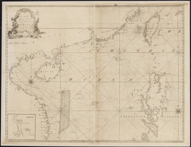
Detail View: Old Maps Collection: A new and correct chart of the coast of China : from latitude 12° north to 26° including Formosa, Hayman and the Philippine Islands.

|
Barcode:
|
3687800317471C
|
|
Title:
|
A new and correct chart of the coast of China : from latitude 12° north to 26° including Formosa, Hayman and the Philippine Islands.
|
|
Other Title:
|
Campello.
|
|
Contributor:
|
W. and J. Mount, T. and T. Page, 1747-1763, publisher, bookseller
|
|
Category:
|
Sea Charts
|
|
Type:
|
Printed
|
|
Language:
|
English
|
|
Create Year:
|
[ca. 17--]
|
|
Format:
|
JPEG 2000, 19887 × 15294, 37MB
|
|
Scale:
|
Scale indeterminable.
|
|
Physical Map Dimension (cm):
|
90 x 118 cm, on sheet 112 x 130 cm
|
|
Note:
|
This chart depicts the South China Sea and part of the Celebes Sea. There is the South China coast with the Hainan Island; on the left the Vietnam East coast, with the Paracels as a grainy inset and some islands on the northwest side, with 'The Triangles' or 'S.t Anthony Girdle or the Brole' on its northeast side. It is also represented the western side of the Philippines Islands, Palawan -Balagant-, Mindoro -Mindovo-, and Luzon -Lucon. Up north it is included the island of Taiwan still named 'Formosa'. This is the first map to feature the English name 'Scarborough Shoal' connected to the small inset west of Manilla.
|
|
Note:
|
Inset 1: Campello. - Scale indeterminable. - 17 x 18 cm.
|
|
Note:
|
Original is a copper plate printed map in two paper sheets, mounted on cloth.
|
|
Note:
|
Title in scroll work phytomorphic cartouche with a depiction of a Pagoda in a Chinese village on the right side.
|
|
Note:
|
There are seven 32-point compass roses on the map with a fleur-de-lis indicating north, two fo them with 16-point stars. Rhumb lines only on waterbodies, with principal winds in bold lines, for half-winds in dashed lines and for quarter-winds in simple lines.
|
|
Note:
|
Both scale lines for the main map and inset in Dutch leagues in black and white interchangeably.
|
|
Note:
|
Relief shown pictorially and bathymetric relief by soundings.
Map with graticule.
|
|
Note:
|
Tropic of Cancer in double line.
|
|
Note:
|
The four borders of the map with latitude and longitude lines in black and white interchangeably.
|
|
Note:
|
Map outlined in simple bold fillet and inset in double fillet.
|
|
Note:
|
Macao in East Indies maps.
|
|
Reference:
|
Geldart, P. Naming Scarborough Shoal: A New and Correct Chart of the Coast of China, The Murillo Bulletin, 4, p. 14-15
|
|
Subject:
|
Nautical charts
|
|
Geographic Area:
|
South China Sea
|
|
Geographic Area:
|
China
|
|
Geographic Area:
|
Vietnam
|
|
Geographic Area:
|
Philippines
|
|
Geographic Area:
|
Paracel Islands
|
|
Geographic Area:
|
Taiwan
|
|
Geographic Area:
|
Philippines
|
|
Geographic Area:
|
Celebes Sea
|
|
Provenance:
|
Bibliothèque Nationale de France
|
|
Provenance Call No.:
|
GE SH 18 PF 182 P 3
|
|
MUST holding:
|
https://must.primo.exlibrisgroup.com/permalink/853MUST_INST/171sgkf/alma991000825439705076
|