Detail View: Old Maps Collection: Dutch Chart of the China Sea
|
Barcode:
|
3687800317483F
|
|
Title:
|
Dutch Chart of the China Sea
|
|
Original Title:
|
[Carte hollandaise de la Mer de Chine]
|
|
Category:
|
Sea Charts
|
|
Type:
|
Manuscripts
|
|
Language:
|
Dutch
|
|
Language:
|
Latin
|
|
Language:
|
Portuguese
|
|
Language:
|
Spanish
|
|
Create Year:
|
[169-]
|
|
Format:
|
JPEG 2000, 11240× 9384, 21MB
|
|
Scale:
|
Scale not given.
|
|
Physical Map Dimension (cm):
|
75 x 93 cm, on sheet 86 x 112 cm
|
|
Note:
|
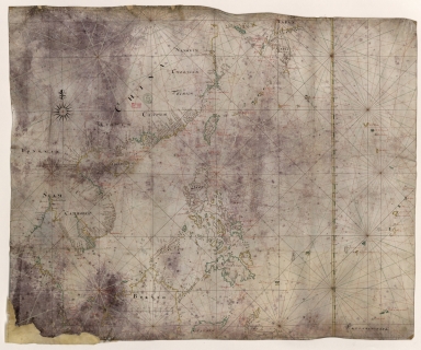
This is a Dutch nautical chart of part of the East China Sea, it was clearly made from a map of the same region by Joan Blaeu in 1687. The chart depicts the Western Pacific, China and Philippine Seas, as for the coast line extends from Malaysia to Nanjing with Korea (Coraij) represented as a small island. The other islands present are the Chinese islands of Hainan and Taiwan, a small part of Sumatra, the north part of Borneo and Philippines and southeast Japan. Near the coast of the Vietnamese East coast are the Paracels in the Vaz Dourado type.
|
|
Note:
|
Original is a manuscript map on parchment, 76 x 92 cm.
|
|
Note:
|
Title from provenance library.
|
|
Note:
|
There is a 32-point compass rose with a fleur-de-lis indicating north. The rhumb lines for the principal winds are in black, for the half-winds in green and for the quarter-winds in red.
|
|
Note:
|
Scale line placed on Borneo Island.
|
|
Note:
|
The coast lines of continents and bigger islands are outlined in yellow, green and magenta with smaller islands painted in the same colors.
|
|
Note:
|
Latitude line on the right side of the chart in yellow and white, and white and green interchangeably.
|
|
Note:
|
Toponyms on land in black and toponyms on water in red.
|
|
Note:
|
Equator in Latin with place names in Dutch, Spanish and Portuguese.
|
|
Note:
|
Macao in East Indies maps.
|
|
Note:
|
Macao in China maps.
|
|
Note:
|
Macao and its surroundings.
|
|
Subject:
|
China -- Maps
|
|
Geographic Area:
|
China
|
|
Geographic Area:
|
China Sea
|
|
Geographic Area:
|
Southeast Asia
|
|
Geographic Area:
|
Hainan Sheng (China)
|
|
Geographic Area:
|
Taiwan
|
|
Geographic Area:
|
Malaysia
|
|
Geographic Area:
|
Cambodia
|
|
Geographic Area:
|
Thailand
|
|
Geographic Area:
|
Vietnam
|
|
Geographic Area:
|
Paracel Islands
|
|
Geographic Area:
|
Korea
|
|
Geographic Area:
|
Japan
|
|
Geographic Area:
|
Borneo
|
|
Geographic Area:
|
Philippines
|
|
Provenance:
|
Bibliothèque Nationale de France
|
|
Provenance:
|
https://catalogue.bnf.fr/ark:/12148/cb407818076
|
|
Provenance Call No.:
|
GE SH 18 PF 181 P 1/1
|
|
MUST holding:
|
https://must.primo.exlibrisgroup.com/permalink/853MUST_INST/171sgkf/alma991000811289705076
|