Detail View: Old Maps Collection: To the Honorable the Court of Directors of the United Company of Merchants of England trading to the East Indies, this Chart of the China Seas
|
Barcode:
|
3687800354287I
|
|
Title:
|
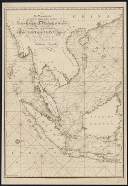
To the Honorable the Court of Directors of the United Company of Merchants of England trading to the East Indies, this Chart of the China Seas
|
|
Other Title:
|
Chart of the China Seas
|
|
Contributor:
|
Heather, William, 1764-1812, hydrographer
|
|
Contributor:
|
Stephenson, John,, fl. 1791-1817, engraver
|
|
Contributor:
|
Norie, John William, 1772-1843, illustrator
|
|
Contributor:
|
Heather and Williams, publisher
|
|
Category:
|
Sea Charts
|
|
Type:
|
Printed
|
|
Language:
|
English
|
|
Create Year:
|
1799
|
|
Format:
|
JPEG 2000, 10897 × 15829, 22MB
|
|
Scale:
|
Scale not given.
|
|
Physical Map Dimension (cm):
|
92 x 64 cm, on sheet 112 x 73 cm
|
|
Note:
|
This detailed chart covers the whole area of the East Indies from Pegu -nowadays Myanmar-, to Siam -nowadays Thailand-, Malaysia, Sumatra, Java, Cambodia, Vietnam and the Paracels, south China with the Hainan Island, Borneo, the island of Taiwan and the Philippines, Timor, Papua New Guinea and part of Australia -still named on the chart as New Holland. As for water bodies are depicted the South China Sea, the Java Sea, the Sulu Sea, Celebes Sea, Banda Sea, Philippine Sea and part of the Pacific Ocean. A lot of detail is given to small islands, islets, shoals and sand banks of the Strait of Malacca, the South China Sea and the Java Sea -named on the map as Borneo Sea. The soundings are also given in extensive detail which proves that navigational aid as the main purpose of the chart. In addiction are marked five routes: the track of the Canton from Columbo towards China in 1797; the Canton from China to England in 1798; to Glatton from China towards England in 1797 (new passage / old passage); Glatton to China in 1976-77 and the track of the Glatton to Manilla.
|
|
Note:
|
Sheet 1: Myanmar, Thailand, Malaysia, Sumatra, Java, Cambodia, Vietnam and the Paracels, south China with the Hainan Island and Borneo.
|
|
Note:
|
Original is a copperplate printed map in two sheets, 94 x 65 cm each.
|
|
Note:
|
Underneath the title: "Engraved by J. Stephenson." On the left bottom corner of sheet 1: "Drawn by J. Norie, teacher of Navigation, Leadenhall Street London."
|
|
Note:
|
Rhumb lines for the principal winds is bold, half-winds in simple fillet and quarter-winds in dashed lines.
|
|
Note:
|
Relief shown pictorially and bathymetric relief shown by soundings.
|
|
Note:
|
Prime meridian is Greenwich.
|
|
Note:
|
The four borders of each sheet have latitude and longitude lines in black and white interchangeably.
|
|
Note:
|
Map with graticule.
|
|
Note:
|
Outlined in simple bold fillet.
|
|
Note:
|
Macao in Asia maps.
|
|
Note:
|
Macao in routes.
|
|
Subject:
|
China -- Maps
|
|
Subject:
|
Southeast Asia -- Maps
|
|
Geographic Area:
|
East Asia
|
|
Geographic Area:
|
South China Sea
|
|
Geographic Area:
|
Java Sea
|
|
Geographic Area:
|
China
|
|
Geographic Area:
|
Hainan Sheng (China)
|
|
Geographic Area:
|
Vietnam
|
|
Geographic Area:
|
Paracel Islands
|
|
Geographic Area:
|
Cambodia
|
|
Geographic Area:
|
Thailand
|
|
Geographic Area:
|
Myanmar
|
|
Geographic Area:
|
Malaysia
|
|
Geographic Area:
|
Malacca (Malacca, Malaysia)
|
|
Geographic Area:
|
Strait of Malacca
|
|
Geographic Area:
|
Java (Indonesia)
|
|
Geographic Area:
|
Sumatra (Indonesia)
|
|
Geographic Area:
|
Borneo
|
|
Provenance:
|
Bibliothèque Nationale de France
|
|
Provenance Call No.:
|
GE SH 18 PF 182 P 14-PL 1
|
|
MUST holding:
|
https://must.primo.exlibrisgroup.com/permalink/853MUST_INST/171sgkf/alma991002988849705076
|