Detail View: Old Maps Collection: A new chart of the China Sea, with its several entrances : drawn from a great number of draughts, journals, and other National documents, regulated by astronomical observation
|
Barcode:
|
3687800354267G
|
|
Title:
|
A new chart of the China Sea, with its several entrances : drawn from a great number of draughts, journals, and other National documents, regulated by astronomical observation
|
|
Other Title:
|
The Islands and coasts between St. Johns and the Great Ladrone
|
|
Other Title:
|
Shitoe Bay enlarged
|
|
Other Title:
|
A sketch of Northumberland Straits 1783
|
|
Contributor:
|
Laurie & Whittle, author, publisher
|
|
Contributor:
|
Larkins, John Pascal, 17---1794, cartographer
|
|
Contributor:
|
Rees, Captain, cartographer
|
|
Category:
|
Sea Charts
|
|
Type:
|
Printed
|
|
Language:
|
English
|
|
Create Year:
|
1794
|
|
Format:
|
JPEG 2000, 10290 × 15519, 22MB
|
|
Scale:
|
[ca. 1:3,700,000].
|
|
Physical Map Dimension (cm):
|
92 x 60 cm, on sheet 112 x 72 cm
|
|
Note:
|
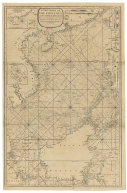
The firm of Robert Laurie and James Whittle had a privileged relationship with both the English East India Company (EIC) and the Royal Navy, and from 1790 to 1810 had special access to the the latest manuscript charts which arrived on ships returning to England from Asia. This highly detailed chart embraces most of the South China Sea, one of the world's busiest shipping corridors. It extends northwards to encompass the southern coasts of China, including Macao, as well as the western coasts of Taiwan and the Philippines. Southwards it details the coasts of Vietnam and Cambodia and the southern tip of the Malay Peninsula. It also encompasses all the Borneo Island, and the adjacent coasts of Sumatra and the Celebes. This chart is extremely detailed with information gained from the observations and surveys of ships employed by the EIC. By the time this chart was produced the Company had been expanding its operations into the South China Sea and it became the definitive map of record used by the EIC and the Royal Navy for a long period of time. On the chart, the seas are crossed with rhumb lines, while inshore areas feature numerous soundings, and the locations of navigational hazards. The routes are mostly dated and identified.
|
|
Note:
|
Inset 1: The Islands and coasts between St. Johns and the Great Ladrone / by Capt.n John Paskall Larkins. - Scale indeterminable. - 12 x 17 cm. -- Inset 2: Shitoe Bay enlarged. - Scale indeterminable. - 5 x 5 cm. -- Inset 3: A sketch of Northumberland Straits 1783 / by Capt.n Rees. - Scale indeterminable. - 12 x 11 cm.
|
|
Note:
|
Original is a copper plate printed map, 91 x 61 cm.
|
|
Note:
|
Scale lines from inset 1 and 2 in miles and inset 3 in leagues.
|
|
Note:
|
There is a 32-point compass rose roughly in the middle of the chart with a fleur de lis indicating north. As for the rhumb lines, the basic and principal winds are represented with a bold fillet, the half winds with a simple fillet and the quarter winds with dotted lines. Illustrations of seven coastal profiles. The first four on board of the 'Royal Captain' in October 1762 by Mr. J. Watson and last three taken by Capt.n Rees.
|
|
Note:
|
Relief shown pictorially and by land forms. Bathymetric relief shown by soundings.
|
|
Note:
|
Map with graticule.
|
|
Note:
|
The four borders of the map with latitude and longitude lines. Equator line in black and white interchangeably.
|
|
Note:
|
Map and insets outlined in double fillet.
|
|
Note:
|
Macao in Routes.
|
|
Note:
|
Macao and its surroundings.
|
|
Reference:
|
Phillips, 4069
|
|
Reference:
|
NLA, https://catalogue.nla.gov.au/Record/4777293?from=list
|
|
Subject:
|
Nautical charts
|
|
Subject:
|
China Sea -- Maps
|
|
Geographic Area:
|
South China Sea
|
|
Geographic Area:
|
Celebes Sea
|
|
Geographic Area:
|
Vietnam
|
|
Geographic Area:
|
Philippines
|
|
Geographic Area:
|
Borneo
|
|
Geographic Area:
|
Taiwan
|
|
Geographic Area:
|
Paracel Islands
|
|
Geographic Area:
|
Sumatra (Indonesia)
|
|
Geographic Area:
|
Hainan Sheng (China)
|
|
Geographic Area:
|
Cambodia
|
|
Geographic Area:
|
Malacca (Malacca, Malaysia)
|
|
Pub Title:
|
Complete East-India pilot, or oriental navigator : being an extensive collection of charts, both general and particular; with plans of bays, roads and harbours, appearances of land, &c.&c., for the navigation not only of the Indian and China seas, with those of New Holland, but also of the seas betwen the British Isles and the Cape of Good-Hope.
|
|
Pub Author:
|
Après de Mannevillette, Jean-Baptiste-Nicolas-Denis d’, 1707-1780
|
|
Pub Year:
|
1800
|
|
Pub location:
|
London
|
|
Provenance:
|
Bibliothèque Nationale de France
|
|
Provenance Call No.:
|
GE SH 18 PF 182 P 10
|
|
MUST holding:
|
https://must.primo.exlibrisgroup.com/permalink/853MUST_INST/171sgkf/alma991000818309705076
|