Detail View: Old Maps Collection: Nouvelle description hydrographique de tout le monde
|
Barcode:
|
4687820501183
|
|
Title:
|
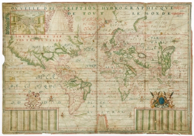
Nouvelle description hydrographique de tout le monde
|
|
Other Title:
|
Description hydrografiq.e du monde
|
|
Other Title:
|
Plan de la ville de Dieppe.
|
|
Other Title:
|
[Grid of latitudes from 0 ° to 80 ° for the northern hemisphere].
|
|
Other Title:
|
Table contenant les quatre annes de la declinaison du soleil, premiere et seconde années.
|
|
Other Title:
|
[Grid of latitudes from 0 ° to 60 ° for the southern hemisphere].
|
|
Other Title:
|
Table contenant les quatre annes de la declinaison du soleil, trois.me et quatre.me années.
|
|
Contributor:
|
Guérard, Jean, 15---1640, cartographer
|
|
Contributor:
|
Lauzon, Jean de, 1584-1666, dedicatee
|
|
Category:
|
Sea Charts
|
|
Type:
|
Manuscripts
|
|
Language:
|
French
|
|
Create Year:
|
1625
|
|
Format:
|
JPEG 2000, 12397 × 8680, 22MB
|
|
Scale:
|
Scale not given.
|
|
Physical Map Dimension (cm):
|
53 x 77 cm, on sheet 60 x 82 cm
|
|
Note:
|
This is a French nautical chart with obvious Portuguese influence both in the depiction and the nomenclature. The place names appear mostly on coast lines and islands while most of the land interior is blank. It is noticeable that Portuguese and Spanish territories in Asia and specially America have a higher number of place names while both the Greenland and North America are underdeveloped and even enlarged. On China it is depicted the Great Wall and Beijing (Paquin) is marked in the form of a castle -even though in a Western style- and houses.
|
|
Note:
|
Inset 1: Plan de la ville de Dieppe. - Scale not given. - 10 x 14 cm. -- Inset 2: [Grid of latitudes from 0 ° to 80 ° for the northern hemisphere]. - 11 x 12 cm. -- Inset 3: Table contenant les quatre annes de la declinaison du soleil, premiere et seconde années. - 9 x 22 cm. -- Inset 3: [Grid of latitudes from 0 ° to 60 ° for the southern hemisphere]. - 7 x 5 cm. -- Inset 4: Table contenant les quatre annes de la declinaison du soleil, troisi.me et quatre.me années. - 9 x 21 cm.
|
|
Note:
|
Original is a manuscript chart on parchment with a manuscript note on the back 'Description hydrografiq.e du monde. p. Guerard. 1625', 51 x 75 cm.
|
|
Note:
|
Title on the upper part of the map with red scrollwork decoration on the right side. There are two complete and two half 32-point compass roses on the map with a fleur de lis indicating north, colored red, blue and gold. Rhumb lines for the principal winds in black, the half-winds in green and quarter-winds in red. Inset 1 is a plan of the coastal community of Dieppe in France, where five sail ships and three sea monsters can be spotted. The port in the Arques river is also very busy. The inset is bordered on the left side by some phytomorphic decorations. Both inset 2 and 4 bordered on the upper, left and right side by scrollwork motives, the former in magenta and the latter in red. Inset 3 and 5 are tables of the declination of the sun during four years. The first is headed by an armillary sphere with the sun, moon and stars on top of it surmounted by a banner with the author's name and the year. The second is headed by two cherubs siding the coat of arms of the dedicatee, Jean de Lauzon, a French Governor of New France from 1651 to 1657.
|
|
Note:
|
Relief shown pictorially.
|
|
Note:
|
Equator line as a longitude line in red, blue and yellow interchangeably. Lines of Tropic of Cancer and Capricorn, Article and Antartic Circle in red.
|
|
Note:
|
Landmasses and big islands outlined in magenta and green with small islands colored red, blue and gold.
|
|
Note:
|
Place names in red and black.
|
|
Note:
|
The four borders of the map with latitude and longitude lines in red, green and gold interchangeably. There is another latitude line roughly in the middle of the map between America and Europe.
|
|
Note:
|
Map outlined in red and green border with scrollwork decoration on the corners. Inset 1 outlined in red and inset 3 and 5 outlined in red and green border.
|
|
Reference:
|
Foncin, M. Catalogue des cartes nautiques sur vélin conservées au Département des cartes et plans, n.º 144, p.
|
|
Reference:
|
Pflederer, R. Census of Portolan Charts & Atlases: as reported and listed by the noted scholars of the genre in their works ranging from 1897 to 2008, p. 59
|
|
Subject:
|
World -- Maps
|
|
Geographic Area:
|
Europe
|
|
Geographic Area:
|
Africa
|
|
Geographic Area:
|
Asia
|
|
Geographic Area:
|
North America
|
|
Geographic Area:
|
South America
|
|
Provenance:
|
Bibliothèque Nationale de France
|
|
Provenance:
|
https://catalogue.bnf.fr/ark:/12148/cb40611771d
|
|
Provenance Call No.:
|
GE SH ARCH-10
|
|
MUST holding:
|
https://must.primo.exlibrisgroup.com/permalink/853MUST_INST/171sgkf/alma991002991549705076
|