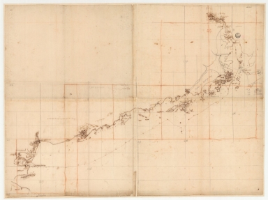
Detail View: Old Maps Collection: Chart of the coasts of China from Hainan Island to Guangzhou
|
Barcode:
|
3687800354661E
|
|
Title:
|
Chart of the coasts of China from Hainan Island to Guangzhou
|
|
Original Title:
|
[Carte des côtes de Chine depuis île de Hainan jusqu'à Canton]
|
|
Category:
|
Sea Charts
|
|
Type:
|
Manuscripts
|
|
Language:
|
French
|
|
Language:
|
Portuguese
|
|
Create Year:
|
[ca. 1701]-[ca. 1702]
|
|
Format:
|
JPEG 2000, 14964 × 11209, 27MB
|
|
Scale:
|
[ca. 1:415,000].
|
|
Physical Map Dimension (cm):
|
91 x 121 cm, on sheet 111 x 132 cm
|
|
Note:
|
This is a map of the coast of South China extending from Donghai Island to Lantao and surroundings islands including Guangzhou (Canton). As it illustrates the voyage of the First French Embassy to China between 1701 and 1702, the soundings given are on the route taken from the L'Amphitrite. Compared to others maps made of said voyage this one is rather more accurate even though some later additions were made graphite.
|
|
Note:
|
Original is a manuscript map, 92 x 122 cm.
|
|
Note:
|
Relief shown pictorially and bathymetric relief by soundings.
|
|
Note:
|
Map with grid.
|
|
Note:
|
Map mainly in French with some place names in Portuguese.
|
|
Note:
|
Macao and its surroundings.
|
|
Subject:
|
Coats
|
|
Geographic Area:
|
Guangdong Sheng (China)
|
|
Geographic Area:
|
Hainan Sheng (China)
|
|
Geographic Area:
|
Macao (China)
|
|
Geographic Area:
|
China
|
|
Provenance:
|
Bibliothèque Nationale de France
|
|
Provenance:
|
https://catalogue.bnf.fr/ark:/12148/cb45085515f
|
|
Provenance Call No.:
|
GE SH 18 PF 179 DIV 3 P 5
|
|
MUST holding:
|
https://must.primo.exlibrisgroup.com/permalink/853MUST_INST/171sgkf/alma991003032549605076
|