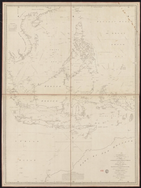
Detail View: Old Maps Collection: To the Society of Managing Owners of the Ships in the English East India Company's Service, This Chart of the China Sea, Including the Philippina Molluca and Banda Islands, Shewing al the same time all the Tracks into the Pacific Ocean, commonly known by the name of the Eastern Passage to China
|
Barcode:
|
36878003222312
|
|
Title:
|
To the Society of Managing Owners of the Ships in the English East India Company's Service, This Chart of the China Sea, Including the Philippina Molluca and Banda Islands, Shewing al the same time all the Tracks into the Pacific Ocean, commonly known by the name of the Eastern Passage to China
|
|
Other Title:
|
Chart of the China Sea, including the Philippina Molluca and Banda Islands
|
|
Contributor:
|
Robertson, George, 1748-1788, cartographer
|
|
Contributor:
|
Harmer, Thomas, fl. 1784-1814, engraver
|
|
Category:
|
Sea Charts
|
|
Type:
|
Printed
|
|
Language:
|
English
|
|
Create Year:
|
1791
|
|
Format:
|
JPEG 2000, 14959 × 19899, 30MB
|
|
Scale:
|
[ca. 1:4,500,000].
|
|
Physical Map Dimension (cm):
|
118 x 90 cm, on sheet 125 x 111 cm
|
|
Note:
|
This sea chart depicts the different routes identified with the name of the person who first sailed it and respective date. It has a legend on the soundings on the left top corner of the left upper sheet. There is an extensive memorandum on the lowest part of the bottom sheets for the route of leaving for Europe from Java. The map was made for the British East India Company with the routes of the China Sea for trade. By the beginning of the 18th century the Company account for half of the world's trade, particularly in basic commodities including cotton, silk, indigo dye, salt, spices, saltpetre, tea, and opium.
|
|
Note:
|
Original map in 4 sheets mounted on cloth.
|
|
Note:
|
Underneath the title: 'Harmar Sculp. 164 Piccadilly'.
|
|
Note:
|
There is an 8-point compass rose with a fleur-de-lis indicating north roughly in the middle of the bottom part of the map. Also indicating north are three fleur-de-lis on the left top corner of the upper sheets and one on the right corner of the right upper sheet.
|
|
Note:
|
Bathymetric relief shown by soundings.
|
|
Note:
|
Prime meridian: Greenwich.
|
|
Note:
|
The four borders of the map with latitude and longitude lines in black and white interchangeably.
|
|
Note:
|
Map outlined in double fillet.
|
|
Note:
|
Macao in East Indies maps.
|
|
Subject:
|
China -- Maps
|
|
Subject:
|
Southeast Asia -- Maps
|
|
Geographic Area:
|
China
|
|
Geographic Area:
|
China Sea
|
|
Geographic Area:
|
Southeast Asia
|
|
Geographic Area:
|
Hainan Sheng (China)
|
|
Geographic Area:
|
Paracel Islands
|
|
Geographic Area:
|
Cambodia
|
|
Geographic Area:
|
Borneo
|
|
Geographic Area:
|
Philippines
|
|
Geographic Area:
|
Taiwan
|
|
Geographic Area:
|
Indonesia
|
|
Geographic Area:
|
Java (Indonesia)
|
|
Geographic Area:
|
Sumatra (Indonesia)
|
|
Geographic Area:
|
Malacca (Malacca, Malaysia)
|
|
Geographic Area:
|
Timor Island
|
|
Geographic Area:
|
Papua New Guinea
|
|
Geographic Area:
|
Australia
|
|
Provenance:
|
Bibliothèque Nationale de France
|
|
Provenance Call No.:
|
GE SH 18 PF 182 P 8
|
|
MUST holding:
|
https://must.primo.exlibrisgroup.com/permalink/853MUST_INST/171sgkf/alma991000811149705076
|