Detail View: Old Maps Collection: Plan of the coast of China from Kittow point to Limpo River
|
Barcode:
|
4687820500138
|
|
Title:
|
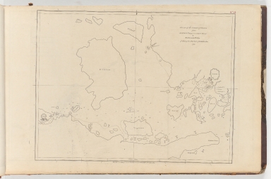
Plan of the coast of China from Kittow point to Limpo River
|
|
Original Title:
|
Plan of the coast of China from Kittow point to Limpo River
|
|
Contributor:
|
Wallis, Ferdinando
|
|
Category:
|
Thematic Maps
|
|
Type:
|
Printed
|
|
Language:
|
English
|
|
Create Year:
|
1783
|
|
Format:
|
JPEG, 9126 × 6058, 56.9MB
|
|
Scale:
|
Scale not given
|
|
Note:
|
Map of the coast of China from Kittow Point to Limpo River showing anchorages and depths by soundings. Situation date: 1755.
|
|
Subject:
|
Coasts
|
|
Geographic Area:
|
Ningbo Shi (China)
|
|
Pub Title:
|
Collection of plans of ports in the East Indies, etc. Vol. 2.
|
|
Pub Author:
|
Dalrymple, Alexander, 1737-1808
|
|
Pub Year:
|
1774-91
|
|
Pub location:
|
[London]
|
|
Provenance:
|
Harvard Map Collection - Harvard College Library
|