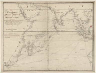
Detail View: Old Maps Collection: Carte reduite de l'Ocean-Oriental ou Mers des Indes : contenant les costes d Afrique dépuis le cap de Bonne-Espérance, jusqu'a la Mer Rouge, et celles d'Asie dépuis la Mer Rouge, jusqu'a Canton en Chine : Avec les Isles de Madagascar, Bourbon, et de France, les Maldives, I. Ceylan, Sumatra, Java, &.a Pour servir aux vaisseaux du Roy
|
Barcode:
|
36878003222413
|
|
Title:
|
Carte reduite de l'Ocean-Oriental ou Mers des Indes : contenant les costes d Afrique dépuis le cap de Bonne-Espérance, jusqu'a la Mer Rouge, et celles d'Asie dépuis la Mer Rouge, jusqu'a Canton en Chine : Avec les Isles de Madagascar, Bourbon, et de France, les Maldives, I. Ceylan, Sumatra, Java, &.a Pour servir aux vaisseaux du Roy
|
|
Other Title:
|
Mers des Indes
|
|
Contributor:
|
Le Moyne, François-Pierre, 1713-1795, cartographer
|
|
Contributor:
|
Maurepas, Jean-Frédéric Phélypeaux, comte de, 1701-1781, patron
|
|
Category:
|
Sea Charts
|
|
Type:
|
Manuscripts
|
|
Language:
|
French
|
|
Create Year:
|
1739
|
|
Format:
|
JPEG 2000, 10070 × 7751, 17MB
|
|
Scale:
|
Scale not given.
|
|
Physical Map Dimension (cm):
|
63 x 81 cm, on sheet 66 x 86 cm
|
|
Note:
|
This important detailed sea chart, made by order of Comte de Maurepas -minister of the French Navy to King Louis XV- depicts the Indian Ocean, surrounding countries and the west coast of Australia -here still named 'Novelle Hollande'. Depicts different navigation itineraries. It is noted on the coast of Australia the first French contact with the Australian coast at Eendracht Land in 1687 by Duquesne-Guitton. It is also recorded the English naming of Shark Bay by Dampier in 1699 and the Dutch visit to Swan River by Vlamingh in 1697. During the 18th century the French navy, under the command of Comte de Maurepas, regained its lost prestige and France was once again recognized as a maritime power. The Indian Ocean increasingly became an area where the French endeavored to expand their influence and so sea charts were required to provide up-to-date information.
|
|
Note:
|
Original is a manuscript map, 67 x 87 cm.
|
|
Note:
|
On the bottom right corner of the map: "Le moine fecit."
|
|
Note:
|
Equator line as longitude line in black and white interchangeably. Tropic of Cancer and Capricorn in double fillet.
|
|
Note:
|
Map with grid.
|
|
Note:
|
The four borders of the mp with latitude and longitude lines in black and white interchangeably.
|
|
Note:
|
Map outlined in bold fillet.
|
|
Note:
|
Macao in east Indies maps.
|
|
Note:
|
Macao in routes.
|
|
Geographic Area:
|
Africa
|
|
Geographic Area:
|
Asia
|
|
Geographic Area:
|
India
|
|
Geographic Area:
|
China
|
|
Geographic Area:
|
Malaysia
|
|
Geographic Area:
|
Cambodia
|
|
Geographic Area:
|
Vietnam
|
|
Geographic Area:
|
Paracel Islands
|
|
Geographic Area:
|
Thailand
|
|
Geographic Area:
|
Indonesia
|
|
Geographic Area:
|
Hainan Island
|
|
Geographic Area:
|
Bornero
|
|
Geographic Area:
|
Australia
|
|
Geographic Area:
|
Indian Ocean
|
|
Provenance:
|
Bibliothèque Nationale de France
|
|
Provenance:
|
https://catalogue.bnf.fr/ark:/12148/cb435470128
|
|
Provenance Call No.:
|
GE SH 18 PF 213 DIV 3 P 22
|
|
MUST holding:
|
https://must.primo.exlibrisgroup.com/permalink/853MUST_INST/171sgkf/alma991000818479705076
|