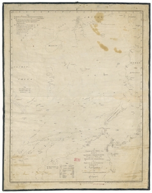
Detail View: Old Maps Collection: A chart of the China Sea : inscribed to Mons.r d'Aprés de Mannevillette the ingenious author of the Neptune Oriental, as a tribute due to his labours for the benefit of navigation, and in acknowledgment of his many signal favours to A. Dalrymple.
|
Barcode:
|
4687820501175
|
|
Title:
|
A chart of the China Sea : inscribed to Mons.r d'Aprés de Mannevillette the ingenious author of the Neptune Oriental, as a tribute due to his labours for the benefit of navigation, and in acknowledgment of his many signal favours to A. Dalrymple.
|
|
Contributor:
|
Dalrymple, Alexander, 1737-1808, hydrographer
|
|
Contributor:
|
Henry, B., fl. 1770-1775, engraver
|
|
Contributor:
|
Whitchurch, William, fl. 18th century, engraver
|
|
Contributor:
|
Lane, Bartholomew, fl. 19th century, engraver
|
|
Contributor:
|
Après de Mannevillette, Jean-Baptiste-Nicolas-Denis d', 1707-1780, dedicatee
|
|
Category:
|
Sea Charts
|
|
Type:
|
Printed
|
|
Language:
|
English
|
|
Language:
|
French
|
|
Language:
|
Spanish
|
|
Create Year:
|
1771
|
|
Format:
|
JPEG 2000, 8407× 10668, 12MB
|
|
Scale:
|
[ca. 1:4,500,000].
|
|
Physical Map Dimension (cm):
|
65 x 50 cm
|
|
Note:
|
During a voyage to China in 1728, Jean d' Aprés de Mannevillette succeeded in correcting the latitudes of many places using new instruments. Back in France he published maps of the route to China, the Red Sea, the coasts of India, Malaya, the northern parts of Indonesia, Indochina and China. The depicted area of this particular chart extends from part of Taiwan -here still named Formosa- in the north, to the Philippines and Borneo in the south, and shows the whole of the coast of Southern China and Vietnam. The China Sea is the busiest waterway in the east thus the importance of such chart. Hundreds of tiny islands are shown and there is little inland and coastal detail.
|
|
Note:
|
Original is a copperplate printed map.
|
|
Note:
|
On the left bottom corner of the map: "Graduated and engraved by B. Henry". On the right corner: "The writing engraved by W. Whitchurch, Bartholomew Lane, Royal Exchange, London."
|
|
Note:
|
Half fleur-de-lis indicating north outside the upper border of the map.
|
|
Note:
|
Bathymetric relief shown by soundings.
|
|
Note:
|
The four borders of the map with latitude and longitude lines.
|
|
Note:
|
Chart with title and legends in English with place names English, French and Spanish.
|
|
Note:
|
Map outlined in simple bold fillet.
|
|
Subject:
|
China -- Maps
|
|
Subject:
|
Nautical Charts
|
|
Geographic Area:
|
China Sea
|
|
Geographic Area:
|
Southeast Asia
|
|
Geographic Area:
|
Southeast China
|
|
Geographic Area:
|
China
|
|
Geographic Area:
|
Philippines
|
|
Geographic Area:
|
Cambodia
|
|
Geographic Area:
|
Vietnam
|
|
Geographic Area:
|
Paracel Islands
|
|
Geographic Area:
|
Hainan Sheng (China)
|
|
Geographic Area:
|
Taiwan
|
|
Geographic Area:
|
Borneo
|
|
Provenance:
|
Bibliothèque Nationale de France
|
|
Provenance Call No.:
|
GE SH 18 PF 181 P 26 D
|
|
MUST holding:
|
https://must.primo.exlibrisgroup.com/permalink/853MUST_INST/171sgkf/alma991000825569705076
|