Detail View: Old Maps Collection: Carte d'une partie de la mer de Chine
|
Barcode:
|
4687820501174
|
|
Title:
|
Carte d'une partie de la mer de Chine
|
|
Contributor:
|
Rosili Mesros, François Etienne de, 1748-1832, bibliographic antecedent
|
|
Category:
|
Sea Charts
|
|
Type:
|
Printed
|
|
Language:
|
French
|
|
Language:
|
Portuguese
|
|
Create Year:
|
1798-1799
|
|
Format:
|
JPEG 2000, 8809 × 12147, 13MB
|
|
Scale:
|
[ca. 1:2,500,000].
|
|
Physical Map Dimension (cm):
|
69 x 50 cm, on sheet 81 x 57 cm
|
|
Note:
|
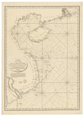
This is a French hydrographic chart of the South China Sea made accordingly to the latest observations of Rosili. The French Vice Admiral spent seven years doing hydrographic work in the Red Sea, the Indian Ocean and the seas off China. In the chart are depicted the northeastern part of the China Sea, with the Pearl River delta, part of the coast of southern China, the Hainan Island, the coast of Vietnam and part of the coast of Cambodia. The Paracel Islands, and other islets and reefs are also present with the route from the frigate Calypso in 1788, commanded by the Count de Kergariou.
|
|
Note:
|
Original is a copperplate printed map, 70 x 50 cm.
|
|
Note:
|
There is an arrow at the center of the map indicating north.
|
|
Note:
|
Relief shown pictorially and bathymetric relief by soundings.
|
|
Note:
|
Map with graticule.
|
|
Note:
|
The four borders of the map with latitude and longitude lines.
|
|
Note:
|
Map outlined in triple fillet.
|
|
Note:
|
Macao in China maps.
|
|
Subject:
|
China -- Maps
|
|
Subject:
|
China Sea -- Maps
|
|
Geographic Area:
|
China
|
|
Geographic Area:
|
South China Sea
|
|
Geographic Area:
|
Hainan Sheng (China)
|
|
Geographic Area:
|
Vietnam -- coasts
|
|
Geographic Area:
|
Cambodia
|
|
Geographic Area:
|
Paracel Islands
|
|
Provenance:
|
Bibliothèque Nationale de France
|
|
Provenance Call No.:
|
GE SH 18 PF 182 P 11-1
|
|
MUST holding:
|
https://must.primo.exlibrisgroup.com/permalink/853MUST_INST/171sgkf/alma991002986849805076
|